Teremendo geodata
Teremendo (State of Mexico) is a populated place; located in Mexico in America/Mexico_City (GMT-6) time zone. With population of 1,366 people, there are 6362 cities with bigger population in this country. Compared to other cities in Mexico, 52.4% of cities are located further ↓South; 77.2% of cities are located further →East and 81.1% of cities have lower elevation than Teremendo. Note1


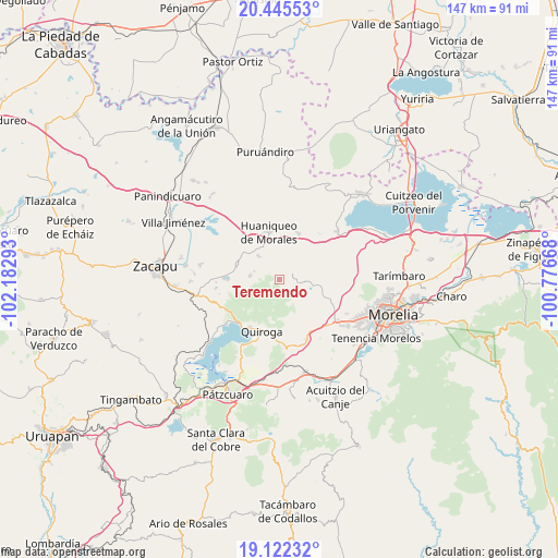
Teremendo GPS coordinates[2]
19° 47' 7.08" North, 101° 28' 47.28" West
| Map corner | latitude | longitude |
|---|---|---|
| Upper-left | 20.44553°, | -102.18293° |
| Center: | 19.7853°, | -101.4798° |
| Lower-right: | 19.12232°, | -100.77668° |
| Map W x H: | 147.1×147.1 km | = 91.4×91.4mi |
| max Lat: | 32.7° ⇑47.6% North |
| Teremendo: | 19.7853° |
| min Lat: | ⇓52.4% South 14.53588° |
| min Long | Teremendo | max Long |
| -117.105° | -101.4798° | -86.73105° |
| W 22.8%⇐ | ⇒77.2% E |
Elevation
Elevation of Teremendo is 2166 m = 7106 ft, and this is 912.3 m = 2993 ft above average elevation for this country.
| Max E: |
3497 m = 11473 ft | 18.9% |
| Teremendo | 2166 m 7106 ft | |
| Avg. | 1253.7 m = 4113 ft | |
Min E: |
-1 m = -3 ft | 81.1% |
See also: Mexico elevation on elevation.city.
Geographical zone
Teremendo is located in North Torrid zone (between Equator and Tropic of Cancer). Distance of this Northern Tropic circle is 406 km =252.3 mi to North.| Distance of | km | miles | from Teremendo |
|---|---|---|---|
| North Pole | 7807.1 | 4851.1 | to North |
| Arctic Circle | 5201.3 | 3231.9 | to North |
| Tropic Cancer | 406 | 252.3 | to North |
| Equator | 2199.9 | 1367 | to South |


Nearby cities:
15 places around Teremendo: (largest is in red/bold)
• Aracurio
1.9 km =1.2 mi,  137°
137°
• Capula
15.5 km =9.6 mi, 143°
• Coeneo de la Libertad
11.7 km =7.3 mi,  290°
290°
• Cuto de la Esperanza
15.8 km =9.8 mi,  112°
112°
• Huaniqueo de Morales
12.7 km =7.9 mi,  348°
348°
• Iratzio
17.1 km =10.6 mi,  155°
155°
• La Cañada
8.3 km =5.2 mi,  318°
318°
• Matugeo
15.4 km =9.6 mi,  247°
247°
• Quiroga
14.1 km =8.8 mi,  198°
198°
• San Isidro
11.7 km =7.3 mi,  307°
307°
• Santa Fé de la Laguna
14.8 km =9.2 mi,  212°
212°
• Tecacho
6.7 km =4.2 mi,  6°
6°
• Tendeparacua
13.3 km =8.3 mi,  21°
21°
• Tungüitiro
13.7 km =8.5 mi,  270°
270°
• Zipiajo
7.7 km =4.8 mi,  277°
277°
Sources, notices
• [Note1] Compared only with cities in Mexico existing in our database
• [Src1] Map data: © OpenStreetMap contributors (CC-BY-SA)
• [Src2] Other city data from geonames.org with taken over terms of usage.
• [Src3] Geographical zone / Annual Mean Temperature by Robert A. Rohde @ Wikipedia
