Tecacho geodata
Tecacho (State of Mexico) is a populated place; located in Mexico in America/Mexico_City (GMT-6) time zone. With population of 803 people, there are 10877 cities with bigger population in this country. Compared to other cities in Mexico, 54% of cities are located further ↓South; 77.2% of cities are located further →East and 75.1% of cities have lower elevation than Tecacho. Note1


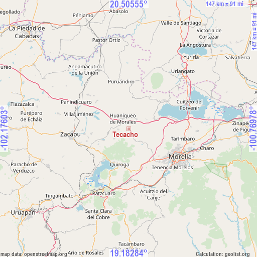
Tecacho GPS coordinates[2]
19° 50' 44.052" North, 101° 28' 22.44" West
| Map corner | latitude | longitude |
|---|---|---|
| Upper-left | 20.50555°, | -102.17603° |
| Center: | 19.84557°, | -101.4729° |
| Lower-right: | 19.18284°, | -100.76978° |
| Map W x H: | 147.1×147.1 km | = 91.4×91.4mi |
| max Lat: | 32.7° ⇑46% North |
| Tecacho: | 19.84557° |
| min Lat: | ⇓54% South 14.53588° |
| min Long | Tecacho | max Long |
| -117.105° | -101.4729° | -86.73105° |
| W 22.8%⇐ | ⇒77.2% E |
Elevation
Elevation of Tecacho is 2033 m = 6670 ft, and this is 779.3 m = 2557 ft above average elevation for this country.
| Max E: |
3497 m = 11473 ft | 24.9% |
| Tecacho | 2033 m 6670 ft | |
| Avg. | 1253.7 m = 4113 ft | |
Min E: |
-1 m = -3 ft | 75.1% |
See also: Mexico elevation on elevation.city.
Geographical zone
Tecacho is located in North Torrid zone (between Equator and Tropic of Cancer). Distance of this Northern Tropic circle is 399.3 km =248.1 mi to North.| Distance of | km | miles | from Tecacho |
|---|---|---|---|
| North Pole | 7800.4 | 4846.9 | to North |
| Arctic Circle | 5194.6 | 3227.8 | to North |
| Tropic Cancer | 399.3 | 248.1 | to North |
| Equator | 2206.6 | 1371.1 | to South |


Nearby cities:
15 places around Tecacho: (largest is in red/bold)
• Aracurio
8.1 km =5 mi,  176°
176°
• Chucándiro
15.8 km =9.8 mi,  67°
67°
• Coeneo de la Libertad
12 km =7.5 mi,  257°
257°
• Cotzurio
18.7 km =11.6 mi,  102°
102°
• Cuto de la Esperanza
18.8 km =11.7 mi,  132°
132°
• El Salitre
17.6 km =10.9 mi, 70°
• Huaniqueo de Morales
6.6 km =4.1 mi,  329°
329°
• La Cañada
6.2 km =3.9 mi,  265°
265°
• Matugeo
19.5 km =12.1 mi,  230°
230°
• San Isidro
10 km =6.2 mi, 272°
• Tendeparacua
7.1 km =4.4 mi,  36°
36°
• Teremendo
6.7 km =4.2 mi,  186°
186°
• Tungüitiro
15.9 km =9.9 mi,  245°
245°
• Villa Morelos
18.6 km =11.6 mi,  19°
19°
• Zipiajo
10.1 km =6.3 mi,  235°
235°
Sources, notices
• [Note1] Compared only with cities in Mexico existing in our database
• [Src1] Map data: © OpenStreetMap contributors (CC-BY-SA)
• [Src2] Other city data from geonames.org with taken over terms of usage.
• [Src3] Geographical zone / Annual Mean Temperature by Robert A. Rohde @ Wikipedia
