Aracurio geodata
Aracurio (Michoacán) is a populated place; located in Mexico in America/Mexico_City (GMT-6) time zone. With population of 688 people, there are 12631 cities with bigger population in this country. Compared to other cities in Mexico, 52% of cities are located further ↓South; 77.1% of cities are located further →East and 83.7% of cities have lower elevation than Aracurio. Note1


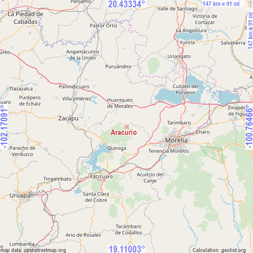
Aracurio GPS coordinates[2]
19° 46' 23.016" North, 101° 28' 4.008" West
| Map corner | latitude | longitude |
|---|---|---|
| Upper-left | 20.43334°, | -102.17091° |
| Center: | 19.77306°, | -101.46778° |
| Lower-right: | 19.11003°, | -100.76466° |
| Map W x H: | 147.1×147.1 km | = 91.4×91.4mi |
| max Lat: | 32.7° ⇑48% North |
| Aracurio: | 19.77306° |
| min Lat: | ⇓52% South 14.53588° |
| min Long | Aracurio | max Long |
| -117.105° | -101.46778° | -86.73105° |
| W 22.9%⇐ | ⇒77.1% E |
Elevation
Elevation of Aracurio is 2237 m = 7339 ft, and this is 983.3 m = 3226 ft above average elevation for this country.
| Max E: |
3497 m = 11473 ft | 16.3% |
| Aracurio | 2237 m 7339 ft | |
| Avg. | 1253.7 m = 4113 ft | |
Min E: |
-1 m = -3 ft | 83.7% |
See also: Mexico elevation on elevation.city.
Geographical zone
Aracurio is located in North Torrid zone (between Equator and Tropic of Cancer). Distance of this Northern Tropic circle is 407.4 km =253.1 mi to North.| Distance of | km | miles | from Aracurio |
|---|---|---|---|
| North Pole | 7808.5 | 4852 | to North |
| Arctic Circle | 5202.6 | 3232.7 | to North |
| Tropic Cancer | 407.4 | 253.1 | to North |
| Equator | 2198.6 | 1366.1 | to South |


Nearby cities:
15 places around Aracurio: (largest is in red/bold)
• Capula
13.6 km =8.5 mi,  144°
144°
• Coeneo de la Libertad
13.4 km =8.3 mi,  293°
293°
• Cuto de la Esperanza
14.1 km =8.8 mi,  109°
109°
• Huaniqueo de Morales
14.3 km =8.9 mi,  344°
344°
• Iratzio
15.3 km =9.5 mi,  157°
157°
• La Cañada
10.2 km =6.3 mi,  318°
318°
• Quiroga
13.3 km =8.3 mi,  205°
205°
• San Isidro
13.5 km =8.4 mi,  308°
308°
• Santa Fé de la Laguna
14.4 km =8.9 mi,  219°
219°
• Tacicuaro
16.1 km =10 mi, 135°
• Tecacho
8.1 km =5 mi,  356°
356°
• Tendeparacua
14.2 km =8.8 mi,  15°
15°
• Teremendo
1.9 km =1.2 mi, 317°
• Tungüitiro
15 km =9.3 mi,  275°
275°
• Zipiajo
9.2 km =5.7 mi, 285°
Sources, notices
• [Note1] Compared only with cities in Mexico existing in our database
• [Src1] Map data: © OpenStreetMap contributors (CC-BY-SA)
• [Src2] Other city data from geonames.org with taken over terms of usage.
• [Src3] Geographical zone / Annual Mean Temperature by Robert A. Rohde @ Wikipedia
