Semporna geodata
Semporna (Sabah) is a populated place; located in Malaysia in Asia/Kuching (GMT+8) time zone. With population of 62,641 people, there are 55 cities with bigger population in this country. Compared to other cities in Malaysia, 58.4% of cities are located further ↓South; 100% of cities are located further ←West and 82% of cities have higher elevation than Semporna. Note1


Semporna GPS coordinates[2]
4° 28' 54.408" North, 118° 36' 40.284" East
| Map corner | latitude | longitude |
|---|---|---|
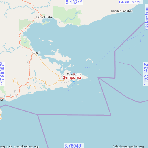
| Upper-left | 5.1824°, | 117.90807° |
| Center: | 4.48178°, | 118.61119° |
| Lower-right: | 3.78049°, | 119.31432° |
| Map W x H: | 155.9×155.9 km | = 96.9×96.9mi |
| max Lat: | 6.88732° ⇑41.6% North |
| Semporna: | 4.48178° |
| min Lat: | ⇓58.4% South 1.24722° |
| min Long | Semporna | max Long |
| 99.68252° | 118.61119° | 118.61119° |
| W 100%⇐ | ⇒0% E |
Elevation
Elevation of Semporna is 7 m = 23 ft, and this is 37.7 m = 124 ft below average elevation for this country.
| Max E: |
1488 m = 4882 ft | 82% |
| Avg. | 44.7 m = 147 ft | |
| Semporna | 7 m = 23 ft | |
Min E: |
0 m = 0 ft | 18% |
See also: Semporna elevation on elevation.city.
Geographical zone
Semporna is located in North Torrid zone (between Equator and Tropic of Cancer). Distance of Equator is 498.3 km =309.6 mi to South.| Distance of | km | miles | from Semporna |
|---|---|---|---|
| North Pole | 9508.7 | 5908.4 | to North |
| Arctic Circle | 6902.8 | 4289.2 | to North |
| Tropic Cancer | 2107.6 | 1309.6 | to North |
| Equator | 498.3 | 309.6 | to South |


Nearby cities:
15 places around Semporna: (largest is in red/bold)
• Beaufort
331.7 km =206.1 mi,  286°
286°
• Donggongon
319.9 km =198.8 mi,  299°
299°
• Keningau
287.7 km =178.8 mi, 289°
• Kg Ramayah
319.5 km =198.5 mi, 299°
• Kinarut
320.8 km =199.3 mi, 297°
• Kota Belud
318.5 km =197.9 mi,  310°
310°
• Kota Kinabalu
326.5 km =202.9 mi, 300°
• Kudat
332.6 km =206.7 mi,  323°
323°
• Lahad Datu
67.8 km =42.1 mi,  332°
332°
• Papar
327.6 km =203.6 mi, 295°
• Putatan
324.8 km =201.8 mi, 299°
• Ranau
270.7 km =168.2 mi, 307°
• Sandakan
160.6 km =99.8 mi,  340°
340°
• Taman Rajawali
169.1 km =105.1 mi, 338°
• Tawau
84.1 km =52.3 mi,  251°
251°
Sources, notices
• [Note1] Compared only with cities in Malaysia existing in our database
• [Src1] Map data: © OpenStreetMap contributors (CC-BY-SA)
• [Src2] Other city data from geonames.org with taken over terms of usage.
• [Src3] Geographical zone / Annual Mean Temperature by Robert A. Rohde @ Wikipedia
