Kg Ramayah geodata
Kg Ramayah (Sabah) is a populated place(s); located in Malaysia in Asia/Kuching (GMT+8) time zone. With population of 600 people, there are 175 cities with bigger population in this country. Compared to other cities in Malaysia, 83.7% of cities are located further ↓South; 94.4% of cities are located further ←West and 55.6% of cities have lower elevation than Kg Ramayah. Note1


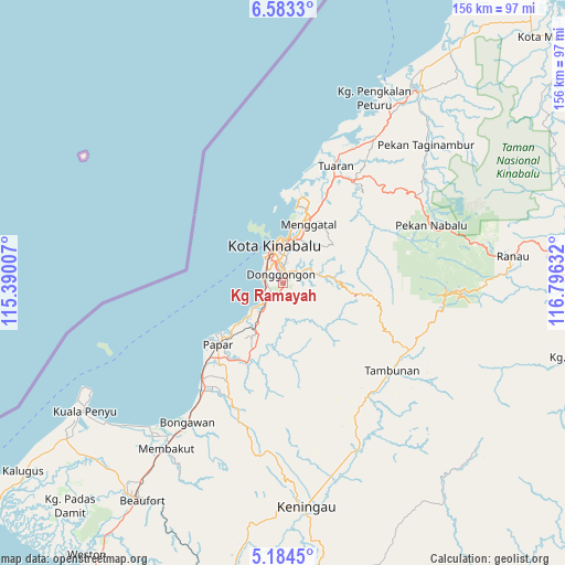
Kg Ramayah GPS coordinates[2]
5° 53' 3.624" North, 116° 5' 35.484" East
| Map corner | latitude | longitude |
|---|---|---|
| Upper-left | 6.5833°, | 115.39007° |
| Center: | 5.88434°, | 116.09319° |
| Lower-right: | 5.1845°, | 116.79632° |
| Map W x H: | 155.5×155.5 km | = 96.6×96.6mi |
| max Lat: | 6.88732° ⇑16.3% North |
| Kg Ramayah: | 5.88434° |
| min Lat: | ⇓83.7% South 1.24722° |
| min Long | Kg Ramayah | max Long |
| 99.68252° | 116.09319° | 118.61119° |
| W 94.4%⇐ | ⇒5.6% E |
Elevation
Elevation of Kg Ramayah is 17 m = 56 ft, and this is 27.7 m = 91 ft below average elevation for this country.
| Max E: |
1488 m = 4882 ft | 44.4% |
| Avg. | 44.7 m = 147 ft | |
| Kg Ramayah | 17 m = 56 ft | |
Min E: |
0 m = 0 ft | 55.6% |
See also: Malaysia elevation on elevation.city.
Geographical zone
Kg Ramayah is located in North Torrid zone (between Equator and Tropic of Cancer). Distance of Equator is 654.3 km =406.6 mi to South.| Distance of | km | miles | from Kg Ramayah |
|---|---|---|---|
| North Pole | 9352.8 | 5811.6 | to North |
| Arctic Circle | 6746.9 | 4192.3 | to North |
| Tropic Cancer | 1951.6 | 1212.7 | to North |
| Equator | 654.3 | 406.6 | to South |


Nearby cities:
15 places around Kg Ramayah: (largest is in red/bold)
• Bandar Labuan
112.7 km =70 mi,  234°
234°
• Beaufort
71 km =44.1 mi,  212°
212°
• Donggongon
2.7 km =1.7 mi,  19°
19°
• Keningau
61.2 km =38 mi,  173°
173°
• Kinarut
8.5 km =5.3 mi,  217°
217°
• Kota Belud
63.9 km =39.7 mi,  35°
35°
• Kota Kinabalu
10.3 km =6.4 mi,  347°
347°
• Kudat
137.7 km =85.6 mi, 35°
• Labuan
115.2 km =71.6 mi, 234°
• Lawas
136.7 km =84.9 mi, 213°
• Limbang
174.8 km =108.6 mi, 223°
• Papar
24.4 km =15.2 mi, 226°
• Putatan
5.8 km =3.6 mi,  322°
322°
• Ranau
63.6 km =39.5 mi,  83°
83°
• Taman Rajawali
216 km =134.2 mi,  89°
89°
Sources, notices
• [Note1] Compared only with cities in Malaysia existing in our database
• [Src1] Map data: © OpenStreetMap contributors (CC-BY-SA)
• [Src2] Other city data from geonames.org with taken over terms of usage.
• [Src3] Geographical zone / Annual Mean Temperature by Robert A. Rohde @ Wikipedia
