Papar geodata
Papar (Sabah) is a populated place; located in Malaysia in Asia/Kuching (GMT+8) time zone. With population of 19,278 people, there are 124 cities with bigger population in this country. Compared to other cities in Malaysia, 78.7% of cities are located further ↓South; 92.1% of cities are located further ←West and 88.8% of cities have higher elevation than Papar. Note1


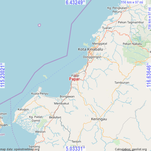
Papar GPS coordinates[2]
5° 43' 59.988" North, 115° 55' 59.988" East
| Map corner | latitude | longitude |
|---|---|---|
| Upper-left | 6.43249°, | 115.23021° |
| Center: | 5.73333°, | 115.93333° |
| Lower-right: | 5.03331°, | 116.63646° |
| Map W x H: | 155.6×155.6 km | = 96.7×96.7mi |
| max Lat: | 6.88732° ⇑21.3% North |
| Papar: | 5.73333° |
| min Lat: | ⇓78.7% South 1.24722° |
| min Long | Papar | max Long |
| 99.68252° | 115.93333° | 118.61119° |
| W 92.1%⇐ | ⇒7.9% E |
Elevation
Elevation of Papar is 6 m = 20 ft, and this is 38.7 m = 127 ft below average elevation for this country.
| Max E: |
1488 m = 4882 ft | 88.8% |
| Avg. | 44.7 m = 147 ft | |
| Papar | 6 m = 20 ft | |
Min E: |
0 m = 0 ft | 11.2% |
See also: Malaysia elevation on elevation.city.
Geographical zone
Papar is located in North Torrid zone (between Equator and Tropic of Cancer). Distance of Equator is 637.5 km =396.1 mi to South.| Distance of | km | miles | from Papar |
|---|---|---|---|
| North Pole | 9369.6 | 5822 | to North |
| Arctic Circle | 6763.7 | 4202.8 | to North |
| Tropic Cancer | 1968.4 | 1223.1 | to North |
| Equator | 637.5 | 396.1 | to South |


Nearby cities:
15 places around Papar: (largest is in red/bold)
• Bandar Labuan
88.6 km =55.1 mi,  236°
236°
• Beaufort
47.7 km =29.6 mi,  205°
205°
• Donggongon
26.8 km =16.7 mi,  43°
43°
• Keningau
50.6 km =31.4 mi,  150°
150°
• Kg Ramayah
24.4 km =15.2 mi,  46°
46°
• Kinarut
16 km =9.9 mi, 51°
• Kota Belud
88 km =54.7 mi, 38°
• Kota Kinabalu
31 km =19.3 mi,  29°
29°
• Kudat
161.7 km =100.5 mi, 37°
• Labuan
91.1 km =56.6 mi, 236°
• Lawas
113.1 km =70.3 mi, 210°
• Limbang
150.4 km =93.5 mi,  223°
223°
• Putatan
25.6 km =15.9 mi, 33°
• Ranau
84.5 km =52.5 mi,  73°
73°
• Taman Rajawali
234.4 km =145.6 mi,  85°
85°
Sources, notices
• [Note1] Compared only with cities in Malaysia existing in our database
• [Src1] Map data: © OpenStreetMap contributors (CC-BY-SA)
• [Src2] Other city data from geonames.org with taken over terms of usage.
• [Src3] Geographical zone / Annual Mean Temperature by Robert A. Rohde @ Wikipedia
