Donggongon geodata
Donggongon (Sabah) is a populated place; located in Malaysia in Asia/Kuching (GMT+8) time zone. With population of 71,585 people, there are 47 cities with bigger population in this country. Compared to other cities in Malaysia, 84.8% of cities are located further ↓South; 94.9% of cities are located further ←West and 51.1% of cities have higher elevation than Donggongon. Note1


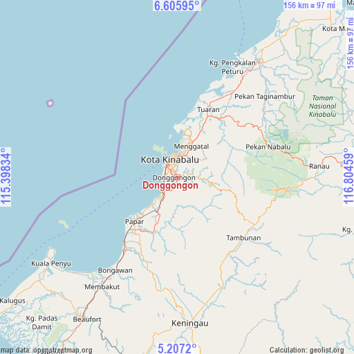
Donggongon GPS coordinates[2]
5° 54' 25.272" North, 116° 6' 5.256" East
| Map corner | latitude | longitude |
|---|---|---|
| Upper-left | 6.60595°, | 115.39834° |
| Center: | 5.90702°, | 116.10146° |
| Lower-right: | 5.2072°, | 116.80459° |
| Map W x H: | 155.5×155.5 km | = 96.6×96.6mi |
| max Lat: | 6.88732° ⇑15.2% North |
| Donggongon: | 5.90702° |
| min Lat: | ⇓84.8% South 1.24722° |
| min Long | Donggongon | max Long |
| 99.68252° | 116.10146° | 118.61119° |
| W 94.9%⇐ | ⇒5.1% E |
Elevation
Elevation of Donggongon is 13 m = 43 ft, and this is 31.7 m = 104 ft below average elevation for this country.
| Max E: |
1488 m = 4882 ft | 51.1% |
| Avg. | 44.7 m = 147 ft | |
| Donggongon | 13 m = 43 ft | |
Min E: |
0 m = 0 ft | 48.9% |
See also: Donggongon elevation on elevation.city.
Geographical zone
Donggongon is located in North Torrid zone (between Equator and Tropic of Cancer). Distance of Equator is 656.8 km =408.1 mi to South.| Distance of | km | miles | from Donggongon |
|---|---|---|---|
| North Pole | 9350.3 | 5810 | to North |
| Arctic Circle | 6744.4 | 4190.8 | to North |
| Tropic Cancer | 1949.1 | 1211.1 | to North |
| Equator | 656.8 | 408.1 | to South |


Nearby cities:
15 places around Donggongon: (largest is in red/bold)
• Bandar Labuan
114.9 km =71.4 mi,  233°
233°
• Beaufort
73.7 km =45.8 mi,  212°
212°
• Keningau
63.6 km =39.5 mi,  174°
174°
• Kg Ramayah
2.7 km =1.7 mi,  199°
199°
• Kinarut
11.1 km =6.9 mi, 213°
• Kota Belud
61.3 km =38.1 mi,  36°
36°
• Kota Kinabalu
8.2 km =5.1 mi,  336°
336°
• Kudat
135.1 km =83.9 mi, 36°
• Labuan
117.4 km =72.9 mi, 233°
• Lawas
139.4 km =86.6 mi, 213°
• Limbang
177.3 km =110.2 mi,  223°
223°
• Papar
26.8 km =16.7 mi, 223°
• Putatan
4.9 km =3 mi,  294°
294°
• Ranau
62.4 km =38.8 mi,  85°
85°
• Taman Rajawali
215 km =133.6 mi, 90°
Sources, notices
• [Note1] Compared only with cities in Malaysia existing in our database
• [Src1] Map data: © OpenStreetMap contributors (CC-BY-SA)
• [Src2] Other city data from geonames.org with taken over terms of usage.
• [Src3] Geographical zone / Annual Mean Temperature by Robert A. Rohde @ Wikipedia
