Kota Kinabalu geodata
Kota Kinabalu (Sabah) is a seat of a first-order administrative division; located in Malaysia in Asia/Kuching (GMT+8) time zone. With population of 457,326 people, there are 10 cities with bigger population in this country. Compared to other cities in Malaysia, 87.6% of cities are located further ↓South; 93.8% of cities are located further ←West and 94.4% of cities have higher elevation than Kota Kinabalu. Note1


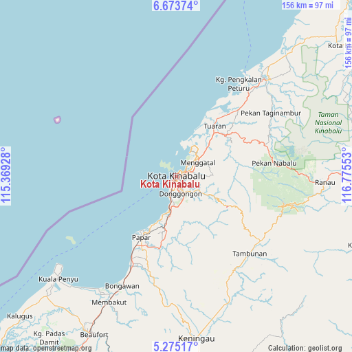
Kota Kinabalu GPS coordinates[2]
5° 58' 29.64" North, 116° 4' 20.64" East
| Map corner | latitude | longitude |
|---|---|---|
| Upper-left | 6.67374°, | 115.36928° |
| Center: | 5.9749°, | 116.0724° |
| Lower-right: | 5.27517°, | 116.77553° |
| Map W x H: | 155.5×155.5 km | = 96.6×96.6mi |
| max Lat: | 6.88732° ⇑12.4% North |
| Kota Kinabalu: | 5.9749° |
| min Lat: | ⇓87.6% South 1.24722° |
| min Long | Kota Kinabalu | max Long |
| 99.68252° | 116.0724° | 118.61119° |
| W 93.8%⇐ | ⇒6.2% E |
Elevation
Elevation of Kota Kinabalu is 5 m = 16 ft, and this is 39.7 m = 130 ft below average elevation for this country.
| Max E: |
1488 m = 4882 ft | 94.4% |
| Avg. | 44.7 m = 147 ft | |
| Kota Kinabalu | 5 m = 16 ft | |
Min E: |
0 m = 0 ft | 5.6% |
See also: Kota Kinabalu elevation on elevation.city.
Geographical zone
Kota Kinabalu is located in North Torrid zone (between Equator and Tropic of Cancer). Distance of Equator is 664.3 km =412.8 mi to South.| Distance of | km | miles | from Kota Kinabalu |
|---|---|---|---|
| North Pole | 9342.7 | 5805.3 | to North |
| Arctic Circle | 6736.8 | 4186.1 | to North |
| Tropic Cancer | 1941.6 | 1206.5 | to North |
| Equator | 664.3 | 412.8 | to South |


Nearby cities:
15 places around Kota Kinabalu: (largest is in red/bold)
• Bandar Labuan
117.1 km =72.8 mi,  229°
229°
• Beaufort
78.6 km =48.8 mi,  207°
207°
• Donggongon
8.2 km =5.1 mi,  156°
156°
• Keningau
71.5 km =44.4 mi,  172°
172°
• Kg Ramayah
10.3 km =6.4 mi, 167°
• Kinarut
17.1 km =10.6 mi,  189°
189°
• Kota Belud
57.6 km =35.8 mi,  43°
43°
• Kudat
131.1 km =81.5 mi, 39°
• Labuan
119.6 km =74.3 mi, 229°
• Lawas
144 km =89.5 mi, 210°
• Limbang
180.7 km =112.3 mi,  221°
221°
• Papar
31 km =19.3 mi, 209°
• Putatan
5.6 km =3.5 mi, 193°
• Ranau
65.5 km =40.7 mi,  92°
92°
• Taman Rajawali
218.4 km =135.7 mi, 92°
Sources, notices
• [Note1] Compared only with cities in Malaysia existing in our database
• [Src1] Map data: © OpenStreetMap contributors (CC-BY-SA)
• [Src2] Other city data from geonames.org with taken over terms of usage.
• [Src3] Geographical zone / Annual Mean Temperature by Robert A. Rohde @ Wikipedia
