Tawau geodata
Tawau (Sabah) is a populated place; located in Malaysia in Asia/Kuching (GMT+8) time zone. With population of 306,462 people, there are 14 cities with bigger population in this country. Compared to other cities in Malaysia, 54.5% of cities are located further ↓South; 97.8% of cities are located further ←West and 56.2% of cities have higher elevation than Tawau. Note1


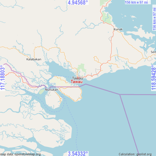
Tawau GPS coordinates[2]
4° 14' 41.352" North, 117° 53' 28.14" East
| Map corner | latitude | longitude |
|---|---|---|
| Upper-left | 4.94568°, | 117.18803° |
| Center: | 4.24482°, | 117.89115° |
| Lower-right: | 3.54332°, | 118.59428° |
| Map W x H: | 155.9×155.9 km | = 96.9×96.9mi |
| max Lat: | 6.88732° ⇑45.5% North |
| Tawau: | 4.24482° |
| min Lat: | ⇓54.5% South 1.24722° |
| min Long | Tawau | max Long |
| 99.68252° | 117.89115° | 118.61119° |
| W 97.8%⇐ | ⇒2.2% E |
Elevation
Elevation of Tawau is 12 m = 39 ft, and this is 32.7 m = 107 ft below average elevation for this country.
| Max E: |
1488 m = 4882 ft | 56.2% |
| Avg. | 44.7 m = 147 ft | |
| Tawau | 12 m = 39 ft | |
Min E: |
0 m = 0 ft | 43.8% |
See also: Tawau elevation on elevation.city.
Geographical zone
Tawau is located in North Torrid zone (between Equator and Tropic of Cancer). Distance of Equator is 472 km =293.3 mi to South.| Distance of | km | miles | from Tawau |
|---|---|---|---|
| North Pole | 9535.1 | 5924.8 | to North |
| Arctic Circle | 6929.2 | 4305.6 | to North |
| Tropic Cancer | 2133.9 | 1325.9 | to North |
| Equator | 472 | 293.3 | to South |


Nearby cities:
15 places around Tawau: (largest is in red/bold)
• Beaufort
267.5 km =166.2 mi,  297°
297°
• Donggongon
271 km =168.4 mi,  312°
312°
• Keningau
227 km =141.1 mi, 302°
• Kg Ramayah
270 km =167.8 mi, 312°
• Kinarut
269.3 km =167.3 mi, 310°
• Kota Belud
284.6 km =176.8 mi,  325°
325°
• Kota Kinabalu
278.5 km =173.1 mi, 313°
• Lahad Datu
99.2 km =61.6 mi,  29°
29°
• Lawas
283.5 km =176.2 mi,  283°
283°
• Papar
272.8 km =169.5 mi, 307°
• Putatan
275.7 km =171.3 mi, 312°
• Ranau
233.6 km =145.2 mi,  324°
324°
• Sandakan
179.2 km =111.3 mi,  8°
8°
• Semporna
84.1 km =52.3 mi,  71°
71°
• Taman Rajawali
184.3 km =114.5 mi, 5°
Sources, notices
• [Note1] Compared only with cities in Malaysia existing in our database
• [Src1] Map data: © OpenStreetMap contributors (CC-BY-SA)
• [Src2] Other city data from geonames.org with taken over terms of usage.
• [Src3] Geographical zone / Annual Mean Temperature by Robert A. Rohde @ Wikipedia
