Beaufort geodata
Beaufort (Sabah) is a populated place; located in Malaysia in Asia/Kuching (GMT+8) time zone. With population of 15,855 people, there are 137 cities with bigger population in this country. Compared to other cities in Malaysia, 70.2% of cities are located further ↓South; 91.6% of cities are located further ←West and 58.4% of cities have lower elevation than Beaufort. Note1


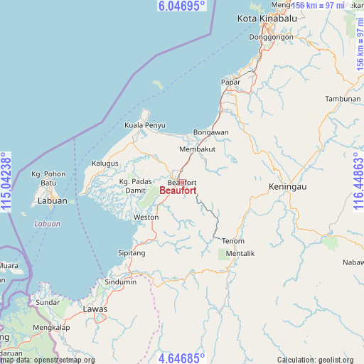
Beaufort GPS coordinates[2]
5° 20' 50.28" North, 115° 44' 43.8" East
| Map corner | latitude | longitude |
|---|---|---|
| Upper-left | 6.04695°, | 115.04238° |
| Center: | 5.3473°, | 115.7455° |
| Lower-right: | 4.64685°, | 116.44863° |
| Map W x H: | 155.7×155.7 km | = 96.7×96.7mi |
| max Lat: | 6.88732° ⇑29.8% North |
| Beaufort: | 5.3473° |
| min Lat: | ⇓70.2% South 1.24722° |
| min Long | Beaufort | max Long |
| 99.68252° | 115.7455° | 118.61119° |
| W 91.6%⇐ | ⇒8.4% E |
Elevation
Elevation of Beaufort is 18 m = 59 ft, and this is 26.7 m = 88 ft below average elevation for this country.
| Max E: |
1488 m = 4882 ft | 41.6% |
| Avg. | 44.7 m = 147 ft | |
| Beaufort | 18 m = 59 ft | |
Min E: |
0 m = 0 ft | 58.4% |
See also: Malaysia elevation on elevation.city.
Geographical zone
Beaufort is located in North Torrid zone (between Equator and Tropic of Cancer). Distance of Equator is 594.6 km =369.5 mi to South.| Distance of | km | miles | from Beaufort |
|---|---|---|---|
| North Pole | 9412.5 | 5848.7 | to North |
| Arctic Circle | 6806.6 | 4229.4 | to North |
| Tropic Cancer | 2011.4 | 1249.8 | to North |
| Equator | 594.6 | 369.5 | to South |


Nearby cities:
15 places around Beaufort: (largest is in red/bold)
• Bandar Labuan
53.1 km =33 mi,  262°
262°
• Donggongon
73.7 km =45.8 mi,  32°
32°
• Keningau
45.9 km =28.5 mi,  91°
91°
• Kg Ramayah
71 km =44.1 mi, 32°
• Kinarut
62.5 km =38.8 mi, 32°
• Kota Belud
134.9 km =83.8 mi, 34°
• Kota Kinabalu
78.6 km =48.8 mi, 27°
• Kudat
208.6 km =129.6 mi, 34°
• Labuan
55.6 km =34.5 mi, 262°
• Lawas
65.7 km =40.8 mi,  214°
214°
• Limbang
106 km =65.9 mi,  231°
231°
• Marudi
204.5 km =127.1 mi, 230°
• Papar
47.7 km =29.6 mi, 25°
• Putatan
73.2 km =45.5 mi, 28°
• Ranau
122 km =75.8 mi,  56°
56°
Sources, notices
• [Note1] Compared only with cities in Malaysia existing in our database
• [Src1] Map data: © OpenStreetMap contributors (CC-BY-SA)
• [Src2] Other city data from geonames.org with taken over terms of usage.
• [Src3] Geographical zone / Annual Mean Temperature by Robert A. Rohde @ Wikipedia
