Tessaoua geodata
Tessaoua (Maradi) is a seat of a second-order administrative division; located in Niger in Africa/Niamey (GMT+1) time zone. With population of 35,775 people, there are 8 cities with bigger population in this country. Compared to other cities in Niger, 55.8% of cities are located further ↑North; 69.8% of cities are located further ←West and 65.1% of cities have lower elevation than Tessaoua. Note1


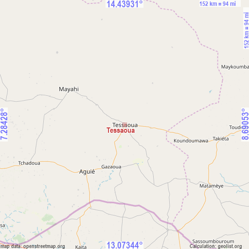
Tessaoua GPS coordinates[2]
13° 45' 26.532" North, 7° 59' 14.64" East
| Map corner | latitude | longitude |
|---|---|---|
| Upper-left | 14.43931°, | 7.28428° |
| Center: | 13.75737°, | 7.9874° |
| Lower-right: | 13.07344°, | 8.69053° |
| Map W x H: | 151.9×151.9 km | = 94.4×94.4mi |
| max Lat: | 18.73694° ⇑55.8% North |
| Tessaoua: | 13.75737° |
| min Lat: | ⇓44.2% South 11.88435° |
| min Long | Tessaoua | max Long |
| 0.75306° | 7.9874° | 13.10921° |
| W 69.8%⇐ | ⇒30.2% E |
Elevation
Elevation of Tessaoua is 400 m = 1312 ft, and this is 57.2 m = 188 ft above average elevation for this country.
| Max E: |
525 m = 1722 ft | 34.9% |
| Tessaoua | 400 m 1312 ft | |
| Avg. | 342.8 m = 1125 ft | |
Min E: |
177 m = 581 ft | 65.1% |
See also: Niger elevation on elevation.city.
Geographical zone
Tessaoua is located in North Torrid zone (between Equator and Tropic of Cancer). Distance of this Northern Tropic circle is 1076.2 km =668.7 mi to North.| Distance of | km | miles | from Tessaoua |
|---|---|---|---|
| North Pole | 8477.4 | 5267.6 | to North |
| Arctic Circle | 5871.5 | 3648.4 | to North |
| Tropic Cancer | 1076.2 | 668.7 | to North |
| Equator | 1529.7 | 950.5 | to South |


Nearby cities:
15 places around Tessaoua: (largest is in red/bold)
• Aguié
35.9 km =22.3 mi,  218°
218°
• Bouza
222.4 km =138.2 mi,  289°
289°
• Dakoro
156.2 km =97.1 mi,  302°
302°
• Guidan Roumdji
140 km =87 mi,  265°
265°
• Kantché
56.8 km =35.3 mi,  115°
115°
• Madaoua
221.6 km =137.7 mi,  279°
279°
• Madarounfa
102.8 km =63.9 mi,  240°
240°
• Magaria
130.7 km =81.2 mi,  130°
130°
• Maradi
99.9 km =62.1 mi,  253°
253°
• Matamey
64.5 km =40.1 mi, 125°
• Mayahi
40.6 km =25.2 mi, 302°
• Mirriah
125.7 km =78.1 mi,  92°
92°
• Tanout
166.2 km =103.3 mi,  35°
35°
• Tibiri
103.7 km =64.4 mi,  257°
257°
• Zinder
108.2 km =67.2 mi, 87°
Sources, notices
• [Note1] Compared only with cities in Niger existing in our database
• [Src1] Map data: © OpenStreetMap contributors (CC-BY-SA)
• [Src2] Other city data from geonames.org with taken over terms of usage.
• [Src3] Geographical zone / Annual Mean Temperature by Robert A. Rohde @ Wikipedia
