Matamey geodata
Matamey (Zinder) is a populated place; located in Niger in Africa/Niamey (GMT+1) time zone. With population of 16,844 people, there are 22 cities with bigger population in this country. Compared to other cities in Niger, 79.1% of cities are located further ↑North; 79.1% of cities are located further ←West and 86% of cities have lower elevation than Matamey. Note1


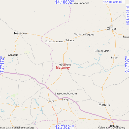
Matamey GPS coordinates[2]
13° 25' 23.124" North, 8° 28' 29.46" East
| Map corner | latitude | longitude |
|---|---|---|
| Upper-left | 14.10602°, | 7.77172° |
| Center: | 13.42309°, | 8.47485° |
| Lower-right: | 12.73821°, | 9.17797° |
| Map W x H: | 152.1×152.1 km | = 94.5×94.5mi |
| max Lat: | 18.73694° ⇑79.1% North |
| Matamey: | 13.42309° |
| min Lat: | ⇓20.9% South 11.88435° |
| min Long | Matamey | max Long |
| 0.75306° | 8.47485° | 13.10921° |
| W 79.1%⇐ | ⇒20.9% E |
Elevation
Elevation of Matamey is 445 m = 1460 ft, and this is 102.2 m = 335 ft above average elevation for this country.
| Max E: |
525 m = 1722 ft | 14% |
| Matamey | 445 m 1460 ft | |
| Avg. | 342.8 m = 1125 ft | |
Min E: |
177 m = 581 ft | 86% |
See also: Niger elevation on elevation.city.
Geographical zone
Matamey is located in North Torrid zone (between Equator and Tropic of Cancer). Distance of this Northern Tropic circle is 1113.4 km =691.8 mi to North.| Distance of | km | miles | from Matamey |
|---|---|---|---|
| North Pole | 8514.6 | 5290.7 | to North |
| Arctic Circle | 5908.7 | 3671.5 | to North |
| Tropic Cancer | 1113.4 | 691.8 | to North |
| Equator | 1492.5 | 927.4 | to South |


Nearby cities:
15 places around Matamey: (largest is in red/bold)
• Aguié
75.8 km =47.1 mi,  276°
276°
• Dakoro
220.6 km =137.1 mi,  303°
303°
• Gouré
203.7 km =126.6 mi,  72°
72°
• Guidan Roumdji
194.1 km =120.6 mi, 277°
• Kantché
13 km =8.1 mi,  354°
354°
• Madaoua
281.1 km =174.7 mi, 284°
• Madarounfa
143.2 km =89 mi,  264°
264°
• Magaria
66.7 km =41.4 mi,  135°
135°
• Maradi
148.7 km =92.4 mi,  273°
273°
• Mayahi
105.1 km =65.3 mi, 304°
• Mirriah
79.5 km =49.4 mi, 66°
• Tanout
177.8 km =110.5 mi,  14°
14°
• Tessaoua
64.5 km =40.1 mi,  305°
305°
• Tibiri
155 km =96.3 mi, 275°
• Zinder
70 km =43.5 mi,  52°
52°
Sources, notices
• [Note1] Compared only with cities in Niger existing in our database
• [Src1] Map data: © OpenStreetMap contributors (CC-BY-SA)
• [Src2] Other city data from geonames.org with taken over terms of usage.
• [Src3] Geographical zone / Annual Mean Temperature by Robert A. Rohde @ Wikipedia
