Mayahi geodata
Mayahi (Maradi) is a seat of a second-order administrative division; located in Niger in Africa/Niamey (GMT+1) time zone. With population of 22,183 people, there are 14 cities with bigger population in this country. Compared to other cities in Niger, 51.2% of cities are located further ↓South; 62.8% of cities are located further ←West and 55.8% of cities have lower elevation than Mayahi. Note1


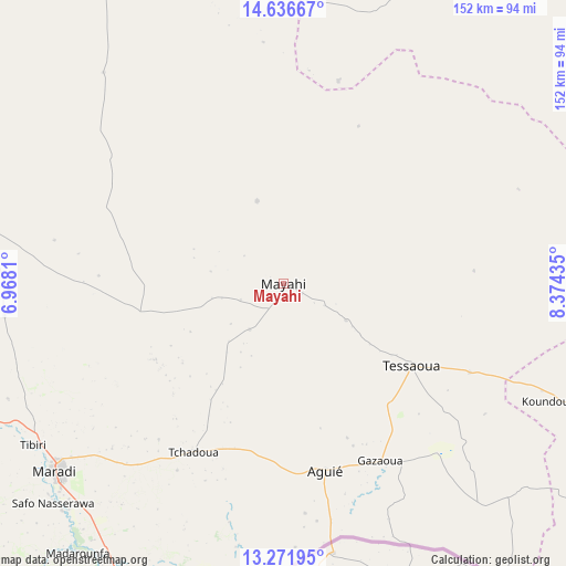
Mayahi GPS coordinates[2]
13° 57' 19.152" North, 7° 40' 16.392" East
| Map corner | latitude | longitude |
|---|---|---|
| Upper-left | 14.63667°, | 6.9681° |
| Center: | 13.95532°, | 7.67122° |
| Lower-right: | 13.27195°, | 8.37435° |
| Map W x H: | 151.7×151.7 km | = 94.3×94.3mi |
| max Lat: | 18.73694° ⇑48.8% North |
| Mayahi: | 13.95532° |
| min Lat: | ⇓51.2% South 11.88435° |
| min Long | Mayahi | max Long |
| 0.75306° | 7.67122° | 13.10921° |
| W 62.8%⇐ | ⇒37.2% E |
Elevation
Elevation of Mayahi is 389 m = 1276 ft, and this is 46.2 m = 152 ft above average elevation for this country.
| Max E: |
525 m = 1722 ft | 44.2% |
| Mayahi | 389 m 1276 ft | |
| Avg. | 342.8 m = 1125 ft | |
Min E: |
177 m = 581 ft | 55.8% |
See also: Niger elevation on elevation.city.
Geographical zone
Mayahi is located in North Torrid zone (between Equator and Tropic of Cancer). Distance of this Northern Tropic circle is 1054.2 km =655 mi to North.| Distance of | km | miles | from Mayahi |
|---|---|---|---|
| North Pole | 8455.4 | 5253.9 | to North |
| Arctic Circle | 5849.5 | 3634.7 | to North |
| Tropic Cancer | 1054.2 | 655 | to North |
| Equator | 1551.7 | 964.2 | to South |


Nearby cities:
15 places around Mayahi: (largest is in red/bold)
• Aguié
51.3 km =31.9 mi,  166°
166°
• Bouza
183.1 km =113.8 mi,  286°
286°
• Dakoro
115.5 km =71.8 mi,  302°
302°
• Guidan Roumdji
110.4 km =68.6 mi,  252°
252°
• Kantché
97.2 km =60.4 mi,  118°
118°
• Madaoua
185.1 km =115 mi,  274°
274°
• Madarounfa
90.9 km =56.5 mi,  217°
217°
• Magaria
171.1 km =106.3 mi,  128°
128°
• Maradi
79.7 km =49.5 mi,  230°
230°
• Matamey
105.1 km =65.3 mi, 124°
• Mirriah
162 km =100.7 mi,  99°
99°
• Tanout
172.9 km =107.4 mi,  49°
49°
• Tessaoua
40.6 km =25.2 mi, 122°
• Tibiri
80.2 km =49.8 mi,  237°
237°
• Zinder
143.1 km =88.9 mi, 96°
Sources, notices
• [Note1] Compared only with cities in Niger existing in our database
• [Src1] Map data: © OpenStreetMap contributors (CC-BY-SA)
• [Src2] Other city data from geonames.org with taken over terms of usage.
• [Src3] Geographical zone / Annual Mean Temperature by Robert A. Rohde @ Wikipedia
