Dakoro geodata
Dakoro (Maradi) is a seat of a second-order administrative division; located in Niger in Africa/Niamey (GMT+1) time zone. With population of 19,798 people, there are 18 cities with bigger population in this country. Compared to other cities in Niger, 74.4% of cities are located further ↓South; 51.2% of cities are located further ←West and 72.1% of cities have lower elevation than Dakoro. Note1


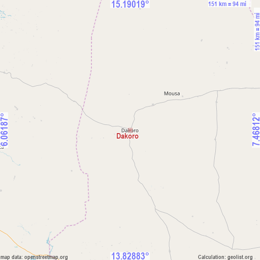
Dakoro GPS coordinates[2]
14° 30' 38.016" North, 6° 45' 54" East
| Map corner | latitude | longitude |
|---|---|---|
| Upper-left | 15.19019°, | 6.06187° |
| Center: | 14.51056°, | 6.765° |
| Lower-right: | 13.82883°, | 7.46812° |
| Map W x H: | 151.4×151.4 km | = 94.1×94.1mi |
| max Lat: | 18.73694° ⇑25.6% North |
| Dakoro: | 14.51056° |
| min Lat: | ⇓74.4% South 11.88435° |
| min Long | Dakoro | max Long |
| 0.75306° | 6.765° | 13.10921° |
| W 51.2%⇐ | ⇒48.8% E |
Elevation
Elevation of Dakoro is 416 m = 1365 ft, and this is 73.2 m = 240 ft above average elevation for this country.
| Max E: |
525 m = 1722 ft | 27.9% |
| Dakoro | 416 m 1365 ft | |
| Avg. | 342.8 m = 1125 ft | |
Min E: |
177 m = 581 ft | 72.1% |
See also: Niger elevation on elevation.city.
Geographical zone
Dakoro is located in North Torrid zone (between Equator and Tropic of Cancer). Distance of this Northern Tropic circle is 992.5 km =616.7 mi to North.| Distance of | km | miles | from Dakoro |
|---|---|---|---|
| North Pole | 8393.6 | 5215.5 | to North |
| Arctic Circle | 5787.8 | 3596.4 | to North |
| Tropic Cancer | 992.5 | 616.7 | to North |
| Equator | 1613.4 | 1002.5 | to South |


Nearby cities:
15 places around Dakoro: (largest is in red/bold)
• Abalak
116.8 km =72.6 mi,  333°
333°
• Aguié
156.3 km =97.1 mi,  135°
135°
• Birni N Konni
181.6 km =112.8 mi,  244°
244°
• Bouza
78.4 km =48.7 mi,  262°
262°
• Guidan Roumdji
95.1 km =59.1 mi,  184°
184°
• Illéla
163.9 km =101.8 mi,  268°
268°
• Keïta
109.9 km =68.3 mi,  284°
284°
• Madaoua
99.5 km =61.8 mi, 240°
• Madarounfa
140.1 km =87.1 mi,  162°
162°
• Maradi
118.1 km =73.4 mi, 162°
• Mayahi
115.5 km =71.8 mi,  122°
122°
• Tahoua
166.3 km =103.3 mi, 284°
• Tchintabaraden
185.8 km =115.5 mi, 326°
• Tessaoua
156.2 km =97.1 mi, 122°
• Tibiri
109.7 km =68.2 mi, 163°
Sources, notices
• [Note1] Compared only with cities in Niger existing in our database
• [Src1] Map data: © OpenStreetMap contributors (CC-BY-SA)
• [Src2] Other city data from geonames.org with taken over terms of usage.
• [Src3] Geographical zone / Annual Mean Temperature by Robert A. Rohde @ Wikipedia
