Yashikera geodata
Yashikera (Kwara) is a populated place; located in Nigeria in Africa/Lagos (GMT+1) time zone. With population of 14,454 people, there are 250 cities with bigger population in this country. Compared to other cities in Nigeria, 61.9% of cities are located further ↓South; 96.2% of cities are located further →East and 72.4% of cities have lower elevation than Yashikera. Note1


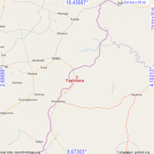
Yashikera GPS coordinates[2]
9° 46' 0.012" North, 3° 24' 0" East
| Map corner | latitude | longitude |
|---|---|---|
| Upper-left | 10.45887°, | 2.69688° |
| Center: | 9.76667°, | 3.4° |
| Lower-right: | 9.07303°, | 4.10313° |
| Map W x H: | 154.1×154.1 km | = 95.8×95.8mi |
| max Lat: | 13.7543° ⇑38.1% North |
| Yashikera: | 9.76667° |
| min Lat: | ⇓61.9% South 4.31231° |
| min Long | Yashikera | max Long |
| 2.73333° | 3.4° | 14.46552° |
| W 3.8%⇐ | ⇒96.2% E |
Elevation
Elevation of Yashikera is 416 m = 1365 ft, and this is 119.5 m = 392 ft above average elevation for this country.
| Max E: |
1599 m = 5246 ft | 27.6% |
| Yashikera | 416 m 1365 ft | |
| Avg. | 296.5 m = 973 ft | |
Min E: |
2 m = 7 ft | 72.4% |
See also: Nigeria elevation on elevation.city.
Geographical zone
Yashikera is located in North Torrid zone (between Equator and Tropic of Cancer). Distance of Equator is 1086 km =674.8 mi to South.| Distance of | km | miles | from Yashikera |
|---|---|---|---|
| North Pole | 8921.1 | 5543.3 | to North |
| Arctic Circle | 6315.2 | 3924.1 | to North |
| Tropic Cancer | 1520 | 944.5 | to North |
| Equator | 1086 | 674.8 | to South |


Nearby cities:
15 places around Yashikera: (largest is in red/bold)
• Ago-Amodu
129.3 km =80.3 mi,  169°
169°
• Babana
86.6 km =53.8 mi,  31°
31°
• Gwasero
33.4 km =20.8 mi,  160°
160°
• Igbeti
138.7 km =86.2 mi,  144°
144°
• Igboho
110.4 km =68.6 mi, 159°
• Kaiama
62 km =38.5 mi,  106°
106°
• Kisi
90.8 km =56.4 mi,  146°
146°
• Kosubosu
30.5 km =19 mi,  218°
218°
• New Bussa
122.2 km =75.9 mi,  83°
83°
• New Shagunnu
133.2 km =82.8 mi,  61°
61°
• Okuta
65.6 km =40.8 mi,  201°
201°
• Saki
122.2 km =75.9 mi,  180°
180°
• Suya
40.9 km =25.4 mi, 215°
• Tede
134.7 km =83.7 mi, 177°
• Wawa
112.7 km =70 mi, 82°
Sources, notices
• [Note1] Compared only with cities in Nigeria existing in our database
• [Src1] Map data: © OpenStreetMap contributors (CC-BY-SA)
• [Src2] Other city data from geonames.org with taken over terms of usage.
• [Src3] Geographical zone / Annual Mean Temperature by Robert A. Rohde @ Wikipedia
