Saki geodata
Saki (Oyo) is a seat of a second-order administrative division; located in Nigeria in Africa/Lagos (GMT+1) time zone. With population of 178,677 people, there are 49 cities with bigger population in this country. Compared to other cities in Nigeria, 52% of cities are located further ↓South; 96.5% of cities are located further →East and 80.3% of cities have lower elevation than Saki. Note1


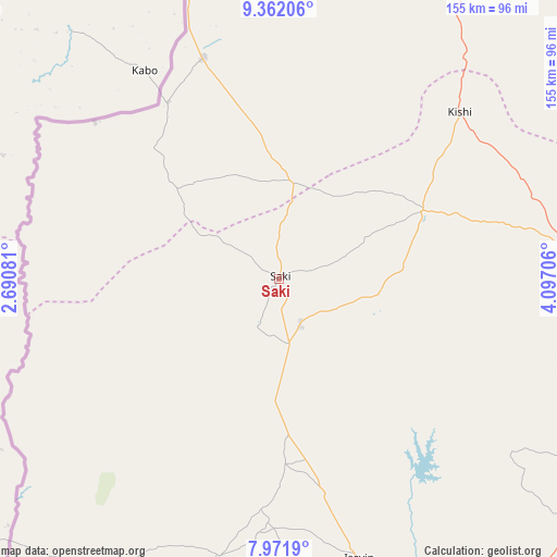
Saki GPS coordinates[2]
8° 40' 3.432" North, 3° 23' 38.148" East
| Map corner | latitude | longitude |
|---|---|---|
| Upper-left | 9.36206°, | 2.69081° |
| Center: | 8.66762°, | 3.39393° |
| Lower-right: | 7.9719°, | 4.09706° |
| Map W x H: | 154.6×154.6 km | = 96.1×96.1mi |
| max Lat: | 13.7543° ⇑48% North |
| Saki: | 8.66762° |
| min Lat: | ⇓52% South 4.31231° |
| min Long | Saki | max Long |
| 2.73333° | 3.39393° | 14.46552° |
| W 3.5%⇐ | ⇒96.5% E |
Elevation
Elevation of Saki is 472 m = 1549 ft, and this is 175.5 m = 576 ft above average elevation for this country.
| Max E: |
1599 m = 5246 ft | 19.7% |
| Saki | 472 m 1549 ft | |
| Avg. | 296.5 m = 973 ft | |
Min E: |
2 m = 7 ft | 80.3% |
See also: Saki elevation on elevation.city.
Geographical zone
Saki is located in North Torrid zone (between Equator and Tropic of Cancer). Distance of Equator is 963.7 km =598.8 mi to South.| Distance of | km | miles | from Saki |
|---|---|---|---|
| North Pole | 9043.3 | 5619.2 | to North |
| Arctic Circle | 6437.4 | 4000 | to North |
| Tropic Cancer | 1642.2 | 1020.4 | to North |
| Equator | 963.7 | 598.8 | to South |


Nearby cities:
15 places around Saki: (largest is in red/bold)
• Ago Are
18.8 km =11.7 mi,  172°
172°
• Ago-Amodu
24.7 km =15.3 mi,  101°
101°
• Gwasero
91.4 km =56.8 mi,  7°
7°
• Igbeti
81.5 km =50.6 mi,  83°
83°
• Igboho
44.1 km =27.4 mi,  64°
64°
• Ikoyi-Ile
97.6 km =60.6 mi,  118°
118°
• Iseyin
80.7 km =50.1 mi,  163°
163°
• Iwere-Ile
81.6 km =50.7 mi,  204°
204°
• Kisi
68.3 km =42.4 mi,  47°
47°
• Kosubosu
99.9 km =62.1 mi,  349°
349°
• Okeho
70.7 km =43.9 mi,  184°
184°
• Okuta
65.3 km =40.6 mi,  339°
339°
• Otu
51.3 km =31.9 mi, 178°
• Suya
91.8 km =57 mi, 345°
• Tede
13.7 km =8.5 mi, 155°
Sources, notices
• [Note1] Compared only with cities in Nigeria existing in our database
• [Src1] Map data: © OpenStreetMap contributors (CC-BY-SA)
• [Src2] Other city data from geonames.org with taken over terms of usage.
• [Src3] Geographical zone / Annual Mean Temperature by Robert A. Rohde @ Wikipedia
