Kaiama geodata
Kaiama (Kwara) is a seat of a second-order administrative division; located in Nigeria in Africa/Lagos (GMT+1) time zone. With population of 21,897 people, there are 188 cities with bigger population in this country. Compared to other cities in Nigeria, 60.3% of cities are located further ↓South; 92.5% of cities are located further →East and 56.9% of cities have lower elevation than Kaiama. Note1


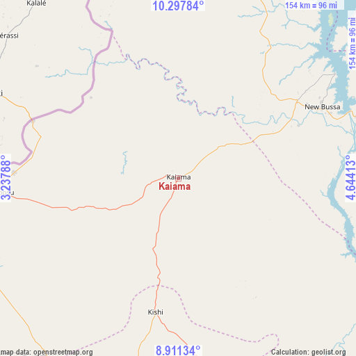
Kaiama GPS coordinates[2]
9° 36' 19.08" North, 3° 56' 27.636" East
| Map corner | latitude | longitude |
|---|---|---|
| Upper-left | 10.29784°, | 3.23788° |
| Center: | 9.6053°, | 3.94101° |
| Lower-right: | 8.91134°, | 4.64413° |
| Map W x H: | 154.2×154.2 km | = 95.8×95.8mi |
| max Lat: | 13.7543° ⇑39.7% North |
| Kaiama: | 9.6053° |
| min Lat: | ⇓60.3% South 4.31231° |
| min Long | Kaiama | max Long |
| 2.73333° | 3.94101° | 14.46552° |
| W 7.5%⇐ | ⇒92.5% E |
Elevation
Elevation of Kaiama is 325 m = 1066 ft, and this is 28.5 m = 94 ft above average elevation for this country.
| Max E: |
1599 m = 5246 ft | 43.1% |
| Kaiama | 325 m 1066 ft | |
| Avg. | 296.5 m = 973 ft | |
Min E: |
2 m = 7 ft | 56.9% |
See also: Nigeria elevation on elevation.city.
Geographical zone
Kaiama is located in North Torrid zone (between Equator and Tropic of Cancer). Distance of Equator is 1068 km =663.6 mi to South.| Distance of | km | miles | from Kaiama |
|---|---|---|---|
| North Pole | 8939.1 | 5554.5 | to North |
| Arctic Circle | 6333.2 | 3935.3 | to North |
| Tropic Cancer | 1537.9 | 955.6 | to North |
| Equator | 1068 | 663.6 | to South |


Nearby cities:
15 places around Kaiama: (largest is in red/bold)
• Auna
107.4 km =66.7 mi,  52°
52°
• Babana
92.7 km =57.6 mi,  351°
351°
• Gwasero
50.2 km =31.2 mi,  254°
254°
• Igbeti
97.4 km =60.5 mi,  167°
167°
• Igboho
87.7 km =54.5 mi,  193°
193°
• Jebba
110.9 km =68.9 mi,  119°
119°
• Kisi
58.9 km =36.6 mi, 189°
• Kosubosu
78.4 km =48.7 mi,  265°
265°
• New Bussa
69.6 km =43.2 mi,  63°
63°
• New Shagunnu
100 km =62.1 mi,  35°
35°
• Okuta
93.7 km =58.2 mi,  242°
242°
• Suya
84.5 km =52.5 mi,  259°
259°
• Wara
102 km =63.4 mi, 47°
• Wawa
61.9 km =38.5 mi, 57°
• Yashikera
62 km =38.5 mi,  286°
286°
Sources, notices
• [Note1] Compared only with cities in Nigeria existing in our database
• [Src1] Map data: © OpenStreetMap contributors (CC-BY-SA)
• [Src2] Other city data from geonames.org with taken over terms of usage.
• [Src3] Geographical zone / Annual Mean Temperature by Robert A. Rohde @ Wikipedia
