Okuta geodata
Okuta (Kwara) is a populated place; located in Nigeria in Africa/Lagos (GMT+1) time zone. With population of 26,589 people, there are 169 cities with bigger population in this country. Compared to other cities in Nigeria, 56.9% of cities are located further ↓South; 99.1% of cities are located further →East and 70.9% of cities have lower elevation than Okuta. Note1


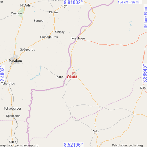
Okuta GPS coordinates[2]
9° 13' 0.012" North, 3° 10' 59.988" East
| Map corner | latitude | longitude |
|---|---|---|
| Upper-left | 9.91002°, | 2.4802° |
| Center: | 9.21667°, | 3.18333° |
| Lower-right: | 8.52196°, | 3.88645° |
| Map W x H: | 154.3×154.3 km | = 95.9×95.9mi |
| max Lat: | 13.7543° ⇑43.1% North |
| Okuta: | 9.21667° |
| min Lat: | ⇓56.9% South 4.31231° |
| min Long | Okuta | max Long |
| 2.73333° | 3.18333° | 14.46552° |
| W 0.9%⇐ | ⇒99.1% E |
Elevation
Elevation of Okuta is 405 m = 1329 ft, and this is 108.5 m = 356 ft above average elevation for this country.
| Max E: |
1599 m = 5246 ft | 29.1% |
| Okuta | 405 m 1329 ft | |
| Avg. | 296.5 m = 973 ft | |
Min E: |
2 m = 7 ft | 70.9% |
See also: Nigeria elevation on elevation.city.
Geographical zone
Okuta is located in North Torrid zone (between Equator and Tropic of Cancer). Distance of Equator is 1024.8 km =636.8 mi to South.| Distance of | km | miles | from Okuta |
|---|---|---|---|
| North Pole | 8982.3 | 5581.3 | to North |
| Arctic Circle | 6376.4 | 3962.1 | to North |
| Tropic Cancer | 1581.1 | 982.4 | to North |
| Equator | 1024.8 | 636.8 | to South |


Nearby cities:
15 places around Okuta: (largest is in red/bold)
• Ago Are
83.7 km =52 mi,  162°
162°
• Ago-Amodu
81.2 km =50.5 mi,  144°
144°
• Gwasero
45.7 km =28.4 mi,  49°
49°
• Igbeti
116.3 km =72.3 mi,  116°
116°
• Igboho
75.7 km =47 mi, 123°
• Iwere-Ile
135.8 km =84.4 mi,  184°
184°
• Kaiama
93.7 km =58.2 mi,  62°
62°
• Kisi
74.9 km =46.5 mi,  101°
101°
• Kosubosu
37.5 km =23.3 mi,  7°
7°
• Okeho
132.7 km =82.5 mi,  172°
172°
• Otu
115 km =71.5 mi, 167°
• Saki
65.3 km =40.6 mi, 159°
• Suya
27.8 km =17.3 mi,  0°
0°
• Tede
78.9 km =49 mi, 158°
• Yashikera
65.6 km =40.8 mi,  21°
21°
Sources, notices
• [Note1] Compared only with cities in Nigeria existing in our database
• [Src1] Map data: © OpenStreetMap contributors (CC-BY-SA)
• [Src2] Other city data from geonames.org with taken over terms of usage.
• [Src3] Geographical zone / Annual Mean Temperature by Robert A. Rohde @ Wikipedia
