New Shagunnu geodata
New Shagunnu (Niger) is a populated place; located in Nigeria in Africa/Lagos (GMT+1) time zone. With population of 7,349 people, there are 405 cities with bigger population in this country. Compared to other cities in Nigeria, 67.2% of cities are located further ↓South; 87.8% of cities are located further →East and 68.7% of cities have higher elevation than New Shagunnu. Note1


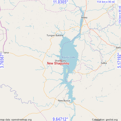
New Shagunnu GPS coordinates[2]
10° 20' 22.452" North, 4° 28' 7.68" East
| Map corner | latitude | longitude |
|---|---|---|
| Upper-left | 11.0305°, | 3.76567° |
| Center: | 10.33957°, | 4.4688° |
| Lower-right: | 9.64712°, | 5.17192° |
| Map W x H: | 153.8×153.8 km | = 95.6×95.6mi |
| max Lat: | 13.7543° ⇑32.8% North |
| New Shagunnu: | 10.33957° |
| min Lat: | ⇓67.2% South 4.31231° |
| min Long | New Shagunnu | max Long |
| 2.73333° | 4.4688° | 14.46552° |
| W 12.2%⇐ | ⇒87.8% E |
Elevation
Elevation of New Shagunnu is 153 m = 502 ft, and this is 143.5 m = 471 ft below average elevation for this country.
| Max E: |
1599 m = 5246 ft | 68.7% |
| Avg. | 296.5 m = 973 ft | |
| New Shagunnu | 153 m = 502 ft | |
Min E: |
2 m = 7 ft | 31.3% |
See also: Nigeria elevation on elevation.city.
Geographical zone
New Shagunnu is located in North Torrid zone (between Equator and Tropic of Cancer). Distance of Equator is 1149.7 km =714.4 mi to South.| Distance of | km | miles | from New Shagunnu |
|---|---|---|---|
| North Pole | 8857.4 | 5503.7 | to North |
| Arctic Circle | 6251.5 | 3884.5 | to North |
| Tropic Cancer | 1456.3 | 904.9 | to North |
| Equator | 1149.7 | 714.4 | to South |


Nearby cities:
15 places around New Shagunnu: (largest is in red/bold)
• Agwara
42.6 km =26.5 mi,  16°
16°
• Auna
32.5 km =20.2 mi,  121°
121°
• Babana
72.2 km =44.9 mi,  277°
277°
• Besse
103.2 km =64.1 mi,  357°
357°
• Bin Yauri
61.8 km =38.4 mi,  37°
37°
• Ibeto
75.7 km =47 mi,  77°
77°
• Kaiama
100 km =62.1 mi,  215°
215°
• Konkwesso
69.4 km =43.1 mi,  324°
324°
• Kontagora
109.8 km =68.2 mi,  86°
86°
• Nasko
50.1 km =31.1 mi,  69°
69°
• New Bussa
50.6 km =31.4 mi,  175°
175°
• Shanga
97.9 km =60.8 mi,  7°
7°
• Wara
20.9 km =13 mi,  126°
126°
• Wawa
48.9 km =30.4 mi,  186°
186°
• Yelwa
62.7 km =39 mi,  28°
28°
Sources, notices
• [Note1] Compared only with cities in Nigeria existing in our database
• [Src1] Map data: © OpenStreetMap contributors (CC-BY-SA)
• [Src2] Other city data from geonames.org with taken over terms of usage.
• [Src3] Geographical zone / Annual Mean Temperature by Robert A. Rohde @ Wikipedia
