Igboho geodata
Igboho (Oyo) is a seat of a second-order administrative division; located in Nigeria in Africa/Lagos (GMT+1) time zone. With population of 136,764 people, there are 61 cities with bigger population in this country. Compared to other cities in Nigeria, 53.1% of cities are located further ↓South; 94.1% of cities are located further →East and 70.9% of cities have lower elevation than Igboho. Note1


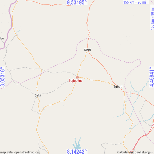
Igboho GPS coordinates[2]
8° 50' 16.224" North, 3° 45' 22.608" East
| Map corner | latitude | longitude |
|---|---|---|
| Upper-left | 9.53195°, | 3.05316° |
| Center: | 8.83784°, | 3.75628° |
| Lower-right: | 8.14242°, | 4.45941° |
| Map W x H: | 154.5×154.5 km | = 96×96mi |
| max Lat: | 13.7543° ⇑46.9% North |
| Igboho: | 8.83784° |
| min Lat: | ⇓53.1% South 4.31231° |
| min Long | Igboho | max Long |
| 2.73333° | 3.75628° | 14.46552° |
| W 5.9%⇐ | ⇒94.1% E |
Elevation
Elevation of Igboho is 405 m = 1329 ft, and this is 108.5 m = 356 ft above average elevation for this country.
| Max E: |
1599 m = 5246 ft | 29.1% |
| Igboho | 405 m 1329 ft | |
| Avg. | 296.5 m = 973 ft | |
Min E: |
2 m = 7 ft | 70.9% |
See also: Igboho elevation on elevation.city.
Geographical zone
Igboho is located in North Torrid zone (between Equator and Tropic of Cancer). Distance of Equator is 982.7 km =610.6 mi to South.| Distance of | km | miles | from Igboho |
|---|---|---|---|
| North Pole | 9024.4 | 5607.5 | to North |
| Arctic Circle | 6418.5 | 3988.3 | to North |
| Tropic Cancer | 1623.2 | 1008.6 | to North |
| Equator | 982.7 | 610.6 | to South |


Nearby cities:
15 places around Igboho: (largest is in red/bold)
• Ago Are
53 km =32.9 mi,  224°
224°
• Ago-Amodu
28.5 km =17.7 mi,  213°
213°
• Alapa
73.2 km =45.5 mi,  109°
109°
• Gwasero
77.1 km =47.9 mi,  338°
338°
• Igbeti
42.4 km =26.3 mi,  103°
103°
• Ikoyi-Ile
80.3 km =49.9 mi,  145°
145°
• Ilorin
94.3 km =58.6 mi, 113°
• Kaiama
87.7 km =54.5 mi,  13°
13°
• Kisi
29.2 km =18.1 mi,  21°
21°
• Ogbomoso
94.7 km =58.8 mi, 145°
• Okuta
75.7 km =47 mi,  303°
303°
• Otu
80 km =49.7 mi, 208°
• Saki
44.1 km =27.4 mi,  244°
244°
• Suya
94 km =58.4 mi,  318°
318°
• Tede
46.3 km =28.8 mi,  227°
227°
Sources, notices
• [Note1] Compared only with cities in Nigeria existing in our database
• [Src1] Map data: © OpenStreetMap contributors (CC-BY-SA)
• [Src2] Other city data from geonames.org with taken over terms of usage.
• [Src3] Geographical zone / Annual Mean Temperature by Robert A. Rohde @ Wikipedia
