Kisi geodata
Kisi (Oyo) is a seat of a second-order administrative division; located in Nigeria in Africa/Lagos (GMT+1) time zone. With population of 155,510 people, there are 57 cities with bigger population in this country. Compared to other cities in Nigeria, 55.8% of cities are located further ↓South; 93.6% of cities are located further →East and 65.4% of cities have lower elevation than Kisi. Note1


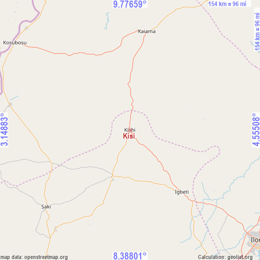
Kisi GPS coordinates[2]
9° 4' 58.692" North, 3° 51' 7.056" East
| Map corner | latitude | longitude |
|---|---|---|
| Upper-left | 9.77659°, | 3.14883° |
| Center: | 9.08297°, | 3.85196° |
| Lower-right: | 8.38801°, | 4.55508° |
| Map W x H: | 154.4×154.4 km | = 95.9×95.9mi |
| max Lat: | 13.7543° ⇑44.2% North |
| Kisi: | 9.08297° |
| min Lat: | ⇓55.8% South 4.31231° |
| min Long | Kisi | max Long |
| 2.73333° | 3.85196° | 14.46552° |
| W 6.4%⇐ | ⇒93.6% E |
Elevation
Elevation of Kisi is 371 m = 1217 ft, and this is 74.5 m = 244 ft above average elevation for this country.
| Max E: |
1599 m = 5246 ft | 34.6% |
| Kisi | 371 m 1217 ft | |
| Avg. | 296.5 m = 973 ft | |
Min E: |
2 m = 7 ft | 65.4% |
See also: Kisi elevation on elevation.city.
Geographical zone
Kisi is located in North Torrid zone (between Equator and Tropic of Cancer). Distance of Equator is 1009.9 km =627.5 mi to South.| Distance of | km | miles | from Kisi |
|---|---|---|---|
| North Pole | 8997.1 | 5590.5 | to North |
| Arctic Circle | 6391.2 | 3971.3 | to North |
| Tropic Cancer | 1596 | 991.7 | to North |
| Equator | 1009.9 | 627.5 | to South |


Nearby cities:
15 places around Kisi: (largest is in red/bold)
• Ago Are
80.6 km =50.1 mi,  216°
216°
• Ago-Amodu
57.4 km =35.7 mi,  207°
207°
• Alapa
78.1 km =48.5 mi,  131°
131°
• Gwasero
58.9 km =36.6 mi,  319°
319°
• Igbeti
48.1 km =29.9 mi,  140°
140°
• Igboho
29.2 km =18.1 mi,  201°
201°
• Ikoyi-Ile
99.6 km =61.9 mi,  159°
159°
• Ilorin
100 km =62.1 mi, 130°
• Kaiama
58.9 km =36.6 mi,  9°
9°
• Kosubosu
86 km =53.4 mi,  307°
307°
• Okuta
74.9 km =46.5 mi,  281°
281°
• Saki
68.3 km =42.4 mi,  227°
227°
• Suya
84.9 km =52.8 mi,  300°
300°
• Tede
73.6 km =45.7 mi, 217°
• Yashikera
90.8 km =56.4 mi,  326°
326°
Sources, notices
• [Note1] Compared only with cities in Nigeria existing in our database
• [Src1] Map data: © OpenStreetMap contributors (CC-BY-SA)
• [Src2] Other city data from geonames.org with taken over terms of usage.
• [Src3] Geographical zone / Annual Mean Temperature by Robert A. Rohde @ Wikipedia
