Tegina geodata
Tegina (Niger) is a populated place; located in Nigeria in Africa/Lagos (GMT+1) time zone. With population of 24,037 people, there are 181 cities with bigger population in this country. Compared to other cities in Nigeria, 65% of cities are located further ↓South; 68.6% of cities are located further →East and 52.3% of cities have higher elevation than Tegina. Note1


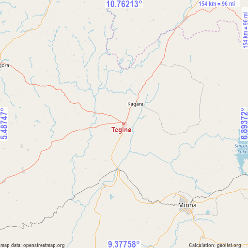
Tegina GPS coordinates[2]
10° 4' 14.16" North, 6° 11' 26.16" East
| Map corner | latitude | longitude |
|---|---|---|
| Upper-left | 10.76213°, | 5.48747° |
| Center: | 10.0706°, | 6.1906° |
| Lower-right: | 9.37758°, | 6.89372° |
| Map W x H: | 153.9×154 km | = 95.6×95.7mi |
| max Lat: | 13.7543° ⇑35% North |
| Tegina: | 10.0706° |
| min Lat: | ⇓65% South 4.31231° |
| min Long | Tegina | max Long |
| 2.73333° | 6.1906° | 14.46552° |
| W 31.4%⇐ | ⇒68.6% E |
Elevation
Elevation of Tegina is 270 m = 886 ft, and this is 26.5 m = 87 ft below average elevation for this country.
| Max E: |
1599 m = 5246 ft | 52.3% |
| Avg. | 296.5 m = 973 ft | |
| Tegina | 270 m = 886 ft | |
Min E: |
2 m = 7 ft | 47.7% |
See also: Nigeria elevation on elevation.city.
Geographical zone
Tegina is located in North Torrid zone (between Equator and Tropic of Cancer). Distance of Equator is 1119.7 km =695.7 mi to South.| Distance of | km | miles | from Tegina |
|---|---|---|---|
| North Pole | 8887.3 | 5522.3 | to North |
| Arctic Circle | 6281.4 | 3903.1 | to North |
| Tropic Cancer | 1486.2 | 923.5 | to North |
| Equator | 1119.7 | 695.7 | to South |


Nearby cities:
15 places around Tegina: (largest is in red/bold)
• Bangi
93.7 km =58.2 mi,  334°
334°
• Birnin Gwari
76.2 km =47.3 mi,  30°
30°
• Kagara
14.7 km =9.1 mi, 28°
• Kontagora
87 km =54.1 mi,  295°
295°
• Kusheriki
58.3 km =36.2 mi, 28°
• Kuta
61.2 km =38 mi,  111°
111°
• Lemu
77.1 km =47.9 mi,  193°
193°
• Maikunkele
53.3 km =33.1 mi,  143°
143°
• Mando
82.8 km =51.4 mi, 29°
• Mashegu
46.4 km =28.8 mi,  256°
256°
• Minna
64 km =39.8 mi, 142°
• Paiko
85.6 km =53.2 mi,  145°
145°
• Ukata
93.5 km =58.1 mi, 334°
• Wushishi
40 km =24.9 mi,  198°
198°
• Zungeru
29.6 km =18.4 mi, 188°
Sources, notices
• [Note1] Compared only with cities in Nigeria existing in our database
• [Src1] Map data: © OpenStreetMap contributors (CC-BY-SA)
• [Src2] Other city data from geonames.org with taken over terms of usage.
• [Src3] Geographical zone / Annual Mean Temperature by Robert A. Rohde @ Wikipedia
