Kagara geodata
Kagara (Niger) is a seat of a second-order administrative division; located in Nigeria in Africa/Lagos (GMT+1) time zone. In our database, there are 451 cities with bigger population. Compared to other cities in Nigeria, 65.5% of cities are located further ↓South; 67.1% of cities are located further →East and 50.3% of cities have lower elevation than Kagara. Note1


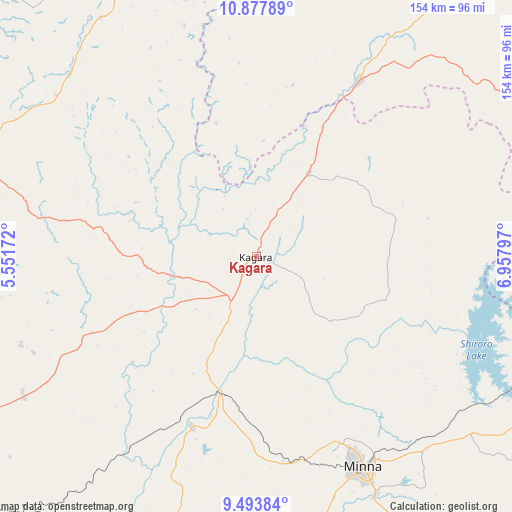
Kagara GPS coordinates[2]
10° 11' 11.832" North, 6° 15' 17.46" East
| Map corner | latitude | longitude |
|---|---|---|
| Upper-left | 10.87789°, | 5.55172° |
| Center: | 10.18662°, | 6.25485° |
| Lower-right: | 9.49384°, | 6.95797° |
| Map W x H: | 153.9×153.9 km | = 95.6×95.6mi |
| max Lat: | 13.7543° ⇑34.5% North |
| Kagara: | 10.18662° |
| min Lat: | ⇓65.5% South 4.31231° |
| min Long | Kagara | max Long |
| 2.73333° | 6.25485° | 14.46552° |
| W 32.9%⇐ | ⇒67.1% E |
Elevation
Elevation of Kagara is 287 m = 942 ft, and this is 9.5 m = 31 ft below average elevation for this country.
| Max E: |
1599 m = 5246 ft | 49.7% |
| Avg. | 296.5 m = 973 ft | |
| Kagara | 287 m = 942 ft | |
Min E: |
2 m = 7 ft | 50.3% |
See also: Nigeria elevation on elevation.city.
Geographical zone
Kagara is located in North Torrid zone (between Equator and Tropic of Cancer). Distance of Equator is 1132.6 km =703.8 mi to South.| Distance of | km | miles | from Kagara |
|---|---|---|---|
| North Pole | 8874.4 | 5514.3 | to North |
| Arctic Circle | 6268.5 | 3895.1 | to North |
| Tropic Cancer | 1473.3 | 915.5 | to North |
| Equator | 1132.6 | 703.8 | to South |


Nearby cities:
15 places around Kagara: (largest is in red/bold)
• Bangi
85.8 km =53.3 mi,  326°
326°
• Birnin Gwari
61.5 km =38.2 mi,  30°
30°
• Kontagora
89.1 km =55.4 mi,  285°
285°
• Kusheriki
43.6 km =27.1 mi, 28°
• Kuta
61.1 km =38 mi,  125°
125°
• Lemu
91.3 km =56.7 mi,  195°
195°
• Maikunkele
61 km =37.9 mi,  156°
156°
• Mando
68.1 km =42.3 mi, 30°
• Mashegu
57.3 km =35.6 mi,  245°
245°
• Minna
71.2 km =44.2 mi,  153°
153°
• Paiko
93.1 km =57.8 mi, 153°
• Tegina
14.7 km =9.1 mi,  208°
208°
• Ukata
85.7 km =53.3 mi, 326°
• Wushishi
54.5 km =33.9 mi, 201°
• Zungeru
43.6 km =27.1 mi,  194°
194°
Sources, notices
• [Note1] Compared only with cities in Nigeria existing in our database
• [Src1] Map data: © OpenStreetMap contributors (CC-BY-SA)
• [Src2] Other city data from geonames.org with taken over terms of usage.
• [Src3] Geographical zone / Annual Mean Temperature by Robert A. Rohde @ Wikipedia
