Ago Are geodata
Ago Are (Oyo) is a populated place; located in Nigeria in Africa/Lagos (GMT+1) time zone. With population of 13,919 people, there are 260 cities with bigger population in this country. Compared to other cities in Nigeria, 51% of cities are located further ↓South; 96% of cities are located further →East and 55.9% of cities have lower elevation than Ago Are. Note1


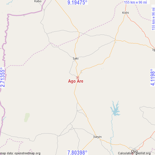
Ago Are GPS coordinates[2]
8° 30' 0" North, 3° 25' 0.012" East
| Map corner | latitude | longitude |
|---|---|---|
| Upper-left | 9.19475°, | 2.71355° |
| Center: | 8.5°, | 3.41667° |
| Lower-right: | 7.80398°, | 4.1198° |
| Map W x H: | 154.6×154.6 km | = 96.1×96.1mi |
| max Lat: | 13.7543° ⇑49% North |
| Ago Are: | 8.5° |
| min Lat: | ⇓51% South 4.31231° |
| min Long | Ago Are | max Long |
| 2.73333° | 3.41667° | 14.46552° |
| W 4%⇐ | ⇒96% E |
Elevation
Elevation of Ago Are is 317 m = 1040 ft, and this is 20.5 m = 67 ft above average elevation for this country.
| Max E: |
1599 m = 5246 ft | 44.1% |
| Ago Are | 317 m 1040 ft | |
| Avg. | 296.5 m = 973 ft | |
Min E: |
2 m = 7 ft | 55.9% |
See also: Nigeria elevation on elevation.city.
Geographical zone
Ago Are is located in North Torrid zone (between Equator and Tropic of Cancer). Distance of Equator is 945.1 km =587.3 mi to South.| Distance of | km | miles | from Ago Are |
|---|---|---|---|
| North Pole | 9062 | 5630.9 | to North |
| Arctic Circle | 6456.1 | 4011.6 | to North |
| Tropic Cancer | 1660.8 | 1032 | to North |
| Equator | 945.1 | 587.3 | to South |


Nearby cities:
15 places around Ago Are: (largest is in red/bold)
• Ago-Amodu
25.7 km =16 mi,  57°
57°
• Igbeti
83.3 km =51.8 mi,  70°
70°
• Igboho
53 km =32.9 mi,  44°
44°
• Ikoyi-Ile
87.8 km =54.6 mi,  108°
108°
• Iseyin
62.1 km =38.6 mi,  161°
161°
• Iwere-Ile
66.4 km =41.3 mi,  212°
212°
• Jobele
98.9 km =61.5 mi,  145°
145°
• Kisi
80.6 km =50.1 mi, 36°
• Ogbomoso
99.3 km =61.7 mi, 114°
• Okeho
52.4 km =32.6 mi,  188°
188°
• Okuta
83.7 km =52 mi,  342°
342°
• Otu
32.7 km =20.3 mi,  181°
181°
• Oyo
91.6 km =56.9 mi,  141°
141°
• Saki
18.8 km =11.7 mi,  352°
352°
• Tede
7.1 km =4.4 mi,  27°
27°
Sources, notices
• [Note1] Compared only with cities in Nigeria existing in our database
• [Src1] Map data: © OpenStreetMap contributors (CC-BY-SA)
• [Src2] Other city data from geonames.org with taken over terms of usage.
• [Src3] Geographical zone / Annual Mean Temperature by Robert A. Rohde @ Wikipedia
