Sarkin Pawa geodata
Sarkin Pawa (Niger) is a seat of a second-order administrative division; located in Nigeria in Africa/Lagos (GMT+1) time zone. In our database, there are 451 cities with bigger population. Compared to other cities in Nigeria, 64.6% of cities are located further ↓South; 53.9% of cities are located further →East and 68.7% of cities have lower elevation than Sarkin Pawa. Note1


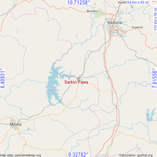
Sarkin Pawa GPS coordinates[2]
10° 1' 15.384" North, 7° 6' 44.784" East
| Map corner | latitude | longitude |
|---|---|---|
| Upper-left | 10.71258°, | 6.40931° |
| Center: | 10.02094°, | 7.11244° |
| Lower-right: | 9.32782°, | 7.81556° |
| Map W x H: | 154×154 km | = 95.7×95.7mi |
| max Lat: | 13.7543° ⇑35.4% North |
| Sarkin Pawa: | 10.02094° |
| min Lat: | ⇓64.6% South 4.31231° |
| min Long | Sarkin Pawa | max Long |
| 2.73333° | 7.11244° | 14.46552° |
| W 46.1%⇐ | ⇒53.9% E |
Elevation
Elevation of Sarkin Pawa is 391 m = 1283 ft, and this is 94.5 m = 310 ft above average elevation for this country.
| Max E: |
1599 m = 5246 ft | 31.3% |
| Sarkin Pawa | 391 m 1283 ft | |
| Avg. | 296.5 m = 973 ft | |
Min E: |
2 m = 7 ft | 68.7% |
See also: Nigeria elevation on elevation.city.
Geographical zone
Sarkin Pawa is located in North Torrid zone (between Equator and Tropic of Cancer). Distance of Equator is 1114.2 km =692.3 mi to South.| Distance of | km | miles | from Sarkin Pawa |
|---|---|---|---|
| North Pole | 8892.8 | 5525.7 | to North |
| Arctic Circle | 6286.9 | 3906.5 | to North |
| Tropic Cancer | 1491.7 | 926.9 | to North |
| Equator | 1114.2 | 692.3 | to South |


Nearby cities:
15 places around Sarkin Pawa: (largest is in red/bold)
• Bwari
87.5 km =54.4 mi,  160°
160°
• Gawu Babangida
83.6 km =51.9 mi,  188°
188°
• Kachia
93.6 km =58.2 mi,  100°
100°
• Kaduna
66.6 km =41.4 mi,  32°
32°
• Kagarko
87.1 km =54.1 mi,  132°
132°
• Kajuru
71 km =44.1 mi,  61°
61°
• Kujama
75.3 km =46.8 mi,  49°
49°
• Kusheriki
92.8 km =57.7 mi,  307°
307°
• Kuta
47.2 km =29.3 mi,  248°
248°
• Maikunkele
78.9 km =49 mi,  241°
241°
• Makera
59.8 km =37.2 mi, 33°
• Minna
76.6 km =47.6 mi,  233°
233°
• Paiko
83.5 km =51.9 mi,  218°
218°
• Sabon Wuse
78.1 km =48.5 mi,  167°
167°
• Suleja
93.7 km =58.2 mi,  175°
175°
Sources, notices
• [Note1] Compared only with cities in Nigeria existing in our database
• [Src1] Map data: © OpenStreetMap contributors (CC-BY-SA)
• [Src2] Other city data from geonames.org with taken over terms of usage.
• [Src3] Geographical zone / Annual Mean Temperature by Robert A. Rohde @ Wikipedia
