Kachia geodata
Kachia (Kaduna) is a seat of a second-order administrative division; located in Nigeria in Africa/Lagos (GMT+1) time zone. With population of 30,893 people, there are 163 cities with bigger population in this country. Compared to other cities in Nigeria, 62.9% of cities are located further ↓South; 62.8% of cities are located further ←West and 97.1% of cities have lower elevation than Kachia. Note1


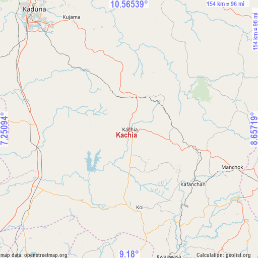
Kachia GPS coordinates[2]
9° 52' 24.312" North, 7° 57' 14.652" East
| Map corner | latitude | longitude |
|---|---|---|
| Upper-left | 10.56539°, | 7.25094° |
| Center: | 9.87342°, | 7.95407° |
| Lower-right: | 9.18°, | 8.65719° |
| Map W x H: | 154×154 km | = 95.7×95.7mi |
| max Lat: | 13.7543° ⇑37.1% North |
| Kachia: | 9.87342° |
| min Lat: | ⇓62.9% South 4.31231° |
| min Long | Kachia | max Long |
| 2.73333° | 7.95407° | 14.46552° |
| W 62.8%⇐ | ⇒37.2% E |
Elevation
Elevation of Kachia is 718 m = 2356 ft, and this is 421.5 m = 1383 ft above average elevation for this country.
| Max E: |
1599 m = 5246 ft | 2.9% |
| Kachia | 718 m 2356 ft | |
| Avg. | 296.5 m = 973 ft | |
Min E: |
2 m = 7 ft | 97.1% |
See also: Nigeria elevation on elevation.city.
Geographical zone
Kachia is located in North Torrid zone (between Equator and Tropic of Cancer). Distance of Equator is 1097.8 km =682.1 mi to South.| Distance of | km | miles | from Kachia |
|---|---|---|---|
| North Pole | 8909.2 | 5535.9 | to North |
| Arctic Circle | 6303.4 | 3916.7 | to North |
| Tropic Cancer | 1508.1 | 937.1 | to North |
| Equator | 1097.8 | 682.1 | to South |


Nearby cities:
15 places around Kachia: (largest is in red/bold)
• Bassa
86.5 km =53.7 mi,  84°
84°
• Bwari
91.2 km =56.7 mi,  223°
223°
• Gwantu
90.5 km =56.2 mi,  142°
142°
• Kafanchan
49.3 km =30.6 mi,  131°
131°
• Kagarko
51 km =31.7 mi,  213°
213°
• Kagoro
56.2 km =34.9 mi,  121°
121°
• Kajuru
58 km =36 mi,  329°
329°
• Kaura
59.8 km =37.2 mi,  112°
112°
• Kauru
81 km =50.3 mi,  15°
15°
• Kujama
73.6 km =45.7 mi, 331°
• Kwoi
46.6 km =29 mi,  172°
172°
• Lere
88.5 km =55 mi,  49°
49°
• Makera
89.2 km =55.4 mi,  318°
318°
• Riyom
91.8 km =57 mi, 106°
• Zonkwa
38.2 km =23.7 mi, 105°
Sources, notices
• [Note1] Compared only with cities in Nigeria existing in our database
• [Src1] Map data: © OpenStreetMap contributors (CC-BY-SA)
• [Src2] Other city data from geonames.org with taken over terms of usage.
• [Src3] Geographical zone / Annual Mean Temperature by Robert A. Rohde @ Wikipedia
