Kajuru geodata
Kajuru (Kaduna) is a seat of a second-order administrative division; located in Nigeria in Africa/Lagos (GMT+1) time zone. With population of 14,389 people, there are 252 cities with bigger population in this country. Compared to other cities in Nigeria, 67.1% of cities are located further ↓South; 57.5% of cities are located further ←West and 96.4% of cities have lower elevation than Kajuru. Note1


Kajuru GPS coordinates[2]
10° 19' 22.116" North, 7° 41' 4.632" East
| Map corner | latitude | longitude |
|---|---|---|
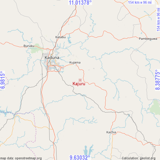
| Upper-left | 11.01378°, | 6.9815° |
| Center: | 10.32281°, | 7.68462° |
| Lower-right: | 9.63032°, | 8.38775° |
| Map W x H: | 153.8×153.8 km | = 95.6×95.6mi |
| max Lat: | 13.7543° ⇑32.9% North |
| Kajuru: | 10.32281° |
| min Lat: | ⇓67.1% South 4.31231° |
| min Long | Kajuru | max Long |
| 2.73333° | 7.68462° | 14.46552° |
| W 57.5%⇐ | ⇒42.5% E |
Elevation
Elevation of Kajuru is 686 m = 2251 ft, and this is 389.5 m = 1278 ft above average elevation for this country.
| Max E: |
1599 m = 5246 ft | 3.6% |
| Kajuru | 686 m 2251 ft | |
| Avg. | 296.5 m = 973 ft | |
Min E: |
2 m = 7 ft | 96.4% |
See also: Nigeria elevation on elevation.city.
Geographical zone
Kajuru is located in North Torrid zone (between Equator and Tropic of Cancer). Distance of Equator is 1147.8 km =713.2 mi to South.| Distance of | km | miles | from Kajuru |
|---|---|---|---|
| North Pole | 8859.3 | 5504.9 | to North |
| Arctic Circle | 6253.4 | 3885.7 | to North |
| Tropic Cancer | 1458.1 | 906 | to North |
| Equator | 1147.8 | 713.2 | to South |


Nearby cities:
15 places around Kajuru: (largest is in red/bold)
• Dutsen Wai
81.2 km =50.5 mi,  43°
43°
• Igabi
53.8 km =33.4 mi,  3°
3°
• Kachia
58 km =36 mi,  149°
149°
• Kaduna
35.1 km =21.8 mi,  310°
310°
• Kagarko
92.5 km =57.5 mi,  179°
179°
• Kauru
58.2 km =36.2 mi,  61°
61°
• Kujama
15.8 km =9.8 mi,  341°
341°
• Kwoi
102.5 km =63.7 mi,  159°
159°
• Lere
97.4 km =60.5 mi,  85°
85°
• Maigana
83.1 km =51.6 mi,  19°
19°
• Makera
34.3 km =21.3 mi,  298°
298°
• Sarkin Pawa
71 km =44.1 mi,  241°
241°
• Soba
83.8 km =52.1 mi,  29°
29°
• Zaria
87.8 km =54.6 mi, 2°
• Zonkwa
89.3 km =55.5 mi,  132°
132°
Sources, notices
• [Note1] Compared only with cities in Nigeria existing in our database
• [Src1] Map data: © OpenStreetMap contributors (CC-BY-SA)
• [Src2] Other city data from geonames.org with taken over terms of usage.
• [Src3] Geographical zone / Annual Mean Temperature by Robert A. Rohde @ Wikipedia
