Kaduna geodata
Kaduna is a seat of a first-order administrative division; located in Nigeria in Africa/Lagos (GMT+1) time zone. With population of 1,582,102 people, there are 3 cities with bigger population in this country. Compared to other cities in Nigeria, 69.4% of cities are located further ↓South; 52.5% of cities are located further ←West and 94% of cities have lower elevation than Kaduna. Note1


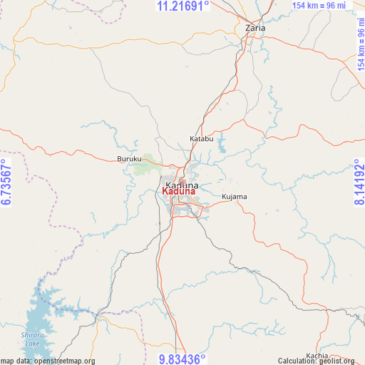
Kaduna GPS coordinates[2]
10° 31' 35.076" North, 7° 26' 19.644" East
| Map corner | latitude | longitude |
|---|---|---|
| Upper-left | 11.21691°, | 6.73567° |
| Center: | 10.52641°, | 7.43879° |
| Lower-right: | 9.83436°, | 8.14192° |
| Map W x H: | 153.7×153.7 km | = 95.5×95.5mi |
| max Lat: | 13.7543° ⇑30.6% North |
| Kaduna: | 10.52641° |
| min Lat: | ⇓69.4% South 4.31231° |
| min Long | Kaduna | max Long |
| 2.73333° | 7.43879° | 14.46552° |
| W 52.5%⇐ | ⇒47.5% E |
Elevation
Elevation of Kaduna is 626 m = 2054 ft, and this is 329.5 m = 1081 ft above average elevation for this country.
| Max E: |
1599 m = 5246 ft | 6% |
| Kaduna | 626 m 2054 ft | |
| Avg. | 296.5 m = 973 ft | |
Min E: |
2 m = 7 ft | 94% |
See also: Kaduna elevation on elevation.city.
Geographical zone
Kaduna is located in North Torrid zone (between Equator and Tropic of Cancer). Distance of Equator is 1170.4 km =727.3 mi to South.| Distance of | km | miles | from Kaduna |
|---|---|---|---|
| North Pole | 8836.6 | 5490.8 | to North |
| Arctic Circle | 6230.7 | 3871.6 | to North |
| Tropic Cancer | 1435.5 | 892 | to North |
| Equator | 1170.4 | 727.3 | to South |


Nearby cities:
15 places around Kaduna: (largest is in red/bold)
• Dutsen Wai
90.5 km =56.2 mi,  66°
66°
• Giwa
87.8 km =54.6 mi,  0°
0°
• Hunkuyi
85.5 km =53.1 mi,  15°
15°
• Igabi
43.3 km =26.9 mi,  44°
44°
• Kachia
91.9 km =57.1 mi,  142°
142°
• Kajuru
35.1 km =21.8 mi,  130°
130°
• Kauru
78 km =48.5 mi,  85°
85°
• Kujama
23.1 km =14.4 mi,  109°
109°
• Maigana
78 km =48.5 mi, 44°
• Makera
6.9 km =4.3 mi,  207°
207°
• Sabuwa
79.9 km =49.6 mi,  334°
334°
• Sarkin Pawa
66.6 km =41.4 mi, 212°
• Soba
84.4 km =52.4 mi,  53°
53°
• Sofo-Birnin-Gwari
90.2 km =56 mi,  307°
307°
• Zaria
72 km =44.7 mi,  25°
25°
Sources, notices
• [Note1] Compared only with cities in Nigeria existing in our database
• [Src1] Map data: © OpenStreetMap contributors (CC-BY-SA)
• [Src2] Other city data from geonames.org with taken over terms of usage.
• [Src3] Geographical zone / Annual Mean Temperature by Robert A. Rohde @ Wikipedia
