Obubra geodata
Obubra (Cross River) is a seat of a second-order administrative division; located in Nigeria in Africa/Lagos (GMT+1) time zone. With population of 12,885 people, there are 276 cities with bigger population in this country. Compared to other cities in Nigeria, 82.8% of cities are located further ↑North; 69.3% of cities are located further ←West and 78.5% of cities have higher elevation than Obubra. Note1


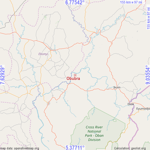
Obubra GPS coordinates[2]
6° 4' 36.192" North, 8° 19' 56.676" East
| Map corner | latitude | longitude |
|---|---|---|
| Upper-left | 6.77542°, | 7.62929° |
| Center: | 6.07672°, | 8.33241° |
| Lower-right: | 5.37711°, | 9.03554° |
| Map W x H: | 155.5×155.5 km | = 96.6×96.6mi |
| max Lat: | 13.7543° ⇑82.8% North |
| Obubra: | 6.07672° |
| min Lat: | ⇓17.2% South 4.31231° |
| min Long | Obubra | max Long |
| 2.73333° | 8.33241° | 14.46552° |
| W 69.3%⇐ | ⇒30.7% E |
Elevation
Elevation of Obubra is 91 m = 299 ft, and this is 205.5 m = 674 ft below average elevation for this country.
| Max E: |
1599 m = 5246 ft | 78.5% |
| Avg. | 296.5 m = 973 ft | |
| Obubra | 91 m = 299 ft | |
Min E: |
2 m = 7 ft | 21.5% |
See also: Nigeria elevation on elevation.city.
Geographical zone
Obubra is located in North Torrid zone (between Equator and Tropic of Cancer). Distance of Equator is 675.7 km =419.9 mi to South.| Distance of | km | miles | from Obubra |
|---|---|---|---|
| North Pole | 9331.4 | 5798.3 | to North |
| Arctic Circle | 6725.5 | 4179 | to North |
| Tropic Cancer | 1930.3 | 1199.4 | to North |
| Equator | 675.7 | 419.9 | to South |


Nearby cities:
15 places around Obubra: (largest is in red/bold)
• Abakaliki
36.7 km =22.8 mi,  318°
318°
• Afikpo
48.4 km =30.1 mi,  245°
245°
• Akpet Central
56.7 km =35.2 mi,  206°
206°
• Effraya
49.5 km =30.8 mi,  119°
119°
• Ezza-Ohu
48.9 km =30.4 mi,  325°
325°
• Ezzamgbo
54.4 km =33.8 mi,  311°
311°
• Iboko
38.3 km =23.8 mi,  343°
343°
• Ikom
43.1 km =26.8 mi,  106°
106°
• Isieke
47.1 km =29.3 mi, 316°
• Isu
59.3 km =36.8 mi,  277°
277°
• Itigidi
40 km =24.9 mi,  239°
239°
• Onuebonyi Echara
20.1 km =12.5 mi, 275°
• Onueke
33.8 km =21 mi,  285°
285°
• Ugbodo
53.3 km =33.1 mi, 335°
• Ugep
40.8 km =25.4 mi,  223°
223°
Sources, notices
• [Note1] Compared only with cities in Nigeria existing in our database
• [Src1] Map data: © OpenStreetMap contributors (CC-BY-SA)
• [Src2] Other city data from geonames.org with taken over terms of usage.
• [Src3] Geographical zone / Annual Mean Temperature by Robert A. Rohde @ Wikipedia
