Afikpo geodata
Afikpo (Ebonyi) is a seat of a second-order administrative division; located in Nigeria in Africa/Lagos (GMT+1) time zone. With population of 71,866 people, there are 129 cities with bigger population in this country. Compared to other cities in Nigeria, 85.1% of cities are located further ↑North; 62.4% of cities are located further ←West and 78.2% of cities have higher elevation than Afikpo. Note1


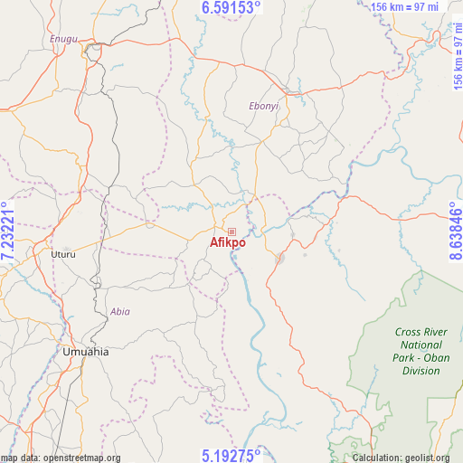
Afikpo GPS coordinates[2]
5° 53' 33.288" North, 7° 56' 7.224" East
| Map corner | latitude | longitude |
|---|---|---|
| Upper-left | 6.59153°, | 7.23221° |
| Center: | 5.89258°, | 7.93534° |
| Lower-right: | 5.19275°, | 8.63846° |
| Map W x H: | 155.5×155.5 km | = 96.6×96.6mi |
| max Lat: | 13.7543° ⇑85.1% North |
| Afikpo: | 5.89258° |
| min Lat: | ⇓14.9% South 4.31231° |
| min Long | Afikpo | max Long |
| 2.73333° | 7.93534° | 14.46552° |
| W 62.4%⇐ | ⇒37.6% E |
Elevation
Elevation of Afikpo is 92 m = 302 ft, and this is 204.5 m = 671 ft below average elevation for this country.
| Max E: |
1599 m = 5246 ft | 78.2% |
| Avg. | 296.5 m = 973 ft | |
| Afikpo | 92 m = 302 ft | |
Min E: |
2 m = 7 ft | 21.8% |
See also: Afikpo elevation on elevation.city.
Geographical zone
Afikpo is located in North Torrid zone (between Equator and Tropic of Cancer). Distance of Equator is 655.2 km =407.1 mi to South.| Distance of | km | miles | from Afikpo |
|---|---|---|---|
| North Pole | 9351.9 | 5811 | to North |
| Arctic Circle | 6746 | 4191.8 | to North |
| Tropic Cancer | 1950.7 | 1212.1 | to North |
| Equator | 655.2 | 407.1 | to South |


Nearby cities:
15 places around Afikpo: (largest is in red/bold)
• Ake-Eze
28.8 km =17.9 mi,  275°
275°
• Akpet Central
35.4 km =22 mi,  148°
148°
• Amaigbo
15.7 km =9.8 mi,  223°
223°
• Ebem Ohafia
31.3 km =19.4 mi,  201°
201°
• Isiaka
43.2 km =26.8 mi,  265°
265°
• Isu
32.2 km =20 mi,  332°
332°
• Itigidi
9.6 km =6 mi,  90°
90°
• Mberubu
46 km =28.6 mi,  312°
312°
• Ndeaboh
43.5 km =27 mi,  291°
291°
• Nguzu Edda
20.1 km =12.5 mi, 220°
• Obiozara
24.8 km =15.4 mi, 313°
• Ohafia-Ifigh
33.8 km =21 mi, 203°
• Onuebonyi Echara
32.9 km =20.4 mi,  46°
46°
• Onueke
31.3 km =19.4 mi,  21°
21°
• Ugep
18.6 km =11.6 mi,  120°
120°
Sources, notices
• [Note1] Compared only with cities in Nigeria existing in our database
• [Src1] Map data: © OpenStreetMap contributors (CC-BY-SA)
• [Src2] Other city data from geonames.org with taken over terms of usage.
• [Src3] Geographical zone / Annual Mean Temperature by Robert A. Rohde @ Wikipedia
