Itigidi geodata
Itigidi (Cross River) is a seat of a second-order administrative division; located in Nigeria in Africa/Lagos (GMT+1) time zone. In our database, there are 451 cities with bigger population. Compared to other cities in Nigeria, 85.2% of cities are located further ↑North; 64.2% of cities are located further ←West and 84% of cities have higher elevation than Itigidi. Note1


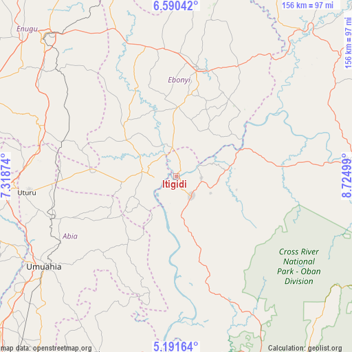
Itigidi GPS coordinates[2]
5° 53' 29.292" North, 8° 1' 18.732" East
| Map corner | latitude | longitude |
|---|---|---|
| Upper-left | 6.59042°, | 7.31874° |
| Center: | 5.89147°, | 8.02187° |
| Lower-right: | 5.19164°, | 8.72499° |
| Map W x H: | 155.5×155.5 km | = 96.6×96.6mi |
| max Lat: | 13.7543° ⇑85.2% North |
| Itigidi: | 5.89147° |
| min Lat: | ⇓14.8% South 4.31231° |
| min Long | Itigidi | max Long |
| 2.73333° | 8.02187° | 14.46552° |
| W 64.2%⇐ | ⇒35.8% E |
Elevation
Elevation of Itigidi is 64 m = 210 ft, and this is 232.5 m = 763 ft below average elevation for this country.
| Max E: |
1599 m = 5246 ft | 84% |
| Avg. | 296.5 m = 973 ft | |
| Itigidi | 64 m = 210 ft | |
Min E: |
2 m = 7 ft | 16% |
See also: Nigeria elevation on elevation.city.
Geographical zone
Itigidi is located in North Torrid zone (between Equator and Tropic of Cancer). Distance of Equator is 655.1 km =407.1 mi to South.| Distance of | km | miles | from Itigidi |
|---|---|---|---|
| North Pole | 9352 | 5811.1 | to North |
| Arctic Circle | 6746.1 | 4191.8 | to North |
| Tropic Cancer | 1950.8 | 1212.2 | to North |
| Equator | 655.1 | 407.1 | to South |


Nearby cities:
15 places around Itigidi: (largest is in red/bold)
• Abakaliki
49.2 km =30.6 mi,  11°
11°
• Afikpo
9.6 km =6 mi,  270°
270°
• Ake-Eze
38.3 km =23.8 mi, 274°
• Akpet Central
31.3 km =19.4 mi,  163°
163°
• Amaigbo
23.3 km =14.5 mi,  240°
240°
• Ebem Ohafia
35.9 km =22.3 mi,  216°
216°
• Isu
37.7 km =23.4 mi,  319°
319°
• Ndeaboh
52.6 km =32.7 mi,  287°
287°
• Nguzu Edda
27.2 km =16.9 mi, 236°
• Obiozara
32.5 km =20.2 mi,  302°
302°
• Obubra
40 km =24.9 mi,  59°
59°
• Ohafia-Ifigh
38.6 km =24 mi, 217°
• Onuebonyi Echara
26.8 km =16.7 mi,  32°
32°
• Onueke
29.4 km =18.3 mi,  3°
3°
• Ugep
11.3 km =7 mi,  144°
144°
Sources, notices
• [Note1] Compared only with cities in Nigeria existing in our database
• [Src1] Map data: © OpenStreetMap contributors (CC-BY-SA)
• [Src2] Other city data from geonames.org with taken over terms of usage.
• [Src3] Geographical zone / Annual Mean Temperature by Robert A. Rohde @ Wikipedia
