Akpet Central geodata
Akpet Central (Cross River) is a seat of a second-order administrative division; located in Nigeria in Africa/Lagos (GMT+1) time zone. In our database, there are 451 cities with bigger population. Compared to other cities in Nigeria, 88.2% of cities are located further ↑North; 65.3% of cities are located further ←West and 75.9% of cities have higher elevation than Akpet Central. Note1


Akpet Central GPS coordinates[2]
5° 37' 15.78" North, 8° 6' 5.868" East
| Map corner | latitude | longitude |
|---|---|---|
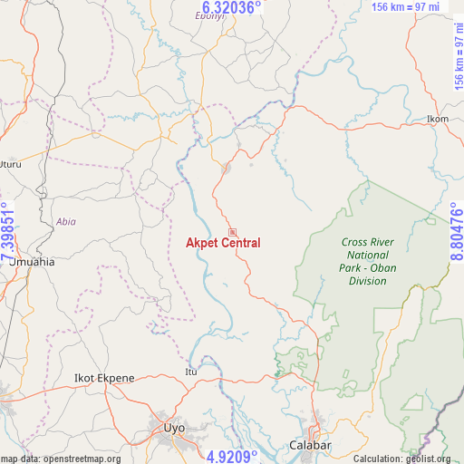
| Upper-left | 6.32036°, | 7.39851° |
| Center: | 5.62105°, | 8.10163° |
| Lower-right: | 4.9209°, | 8.80476° |
| Map W x H: | 155.6×155.6 km | = 96.7×96.7mi |
| max Lat: | 13.7543° ⇑88.2% North |
| Akpet Central: | 5.62105° |
| min Lat: | ⇓11.8% South 4.31231° |
| min Long | Akpet Central | max Long |
| 2.73333° | 8.10163° | 14.46552° |
| W 65.3%⇐ | ⇒34.7% E |
Elevation
Elevation of Akpet Central is 113 m = 371 ft, and this is 183.5 m = 602 ft below average elevation for this country.
| Max E: |
1599 m = 5246 ft | 75.9% |
| Avg. | 296.5 m = 973 ft | |
| Akpet Central | 113 m = 371 ft | |
Min E: |
2 m = 7 ft | 24.1% |
See also: Nigeria elevation on elevation.city.
Geographical zone
Akpet Central is located in North Torrid zone (between Equator and Tropic of Cancer). Distance of Equator is 625 km =388.4 mi to South.| Distance of | km | miles | from Akpet Central |
|---|---|---|---|
| North Pole | 9382.1 | 5829.8 | to North |
| Arctic Circle | 6776.2 | 4210.5 | to North |
| Tropic Cancer | 1980.9 | 1230.9 | to North |
| Equator | 625 | 388.4 | to South |


Nearby cities:
15 places around Akpet Central: (largest is in red/bold)
• Afikpo
35.4 km =22 mi,  328°
328°
• Akamkpa
44.3 km =27.5 mi,  140°
140°
• Amaigbo
34.6 km =21.5 mi,  302°
302°
• Arochukwu
33.2 km =20.6 mi,  219°
219°
• Bende
52.3 km =32.5 mi,  262°
262°
• Ebem Ohafia
30.1 km =18.7 mi,  272°
272°
• Ibiaku Ntok Okpo
55.5 km =34.5 mi,  231°
231°
• Itigidi
31.3 km =19.4 mi,  343°
343°
• Itu
48.5 km =30.1 mi,  195°
195°
• Nguzu Edda
34.8 km =21.6 mi, 295°
• Odoro Ikpe
48.5 km =30.1 mi, 232°
• Ohafia-Ifigh
32.1 km =19.9 mi, 268°
• Oko Ita
52.9 km =32.9 mi,  205°
205°
• Onuebonyi Echara
53 km =32.9 mi,  5°
5°
• Ugep
21 km =13 mi,  353°
353°
Sources, notices
• [Note1] Compared only with cities in Nigeria existing in our database
• [Src1] Map data: © OpenStreetMap contributors (CC-BY-SA)
• [Src2] Other city data from geonames.org with taken over terms of usage.
• [Src3] Geographical zone / Annual Mean Temperature by Robert A. Rohde @ Wikipedia
