Nguzu Edda geodata
Nguzu Edda (Ebonyi) is a seat of a second-order administrative division; located in Nigeria in Africa/Lagos (GMT+1) time zone. In our database, there are 451 cities with bigger population. Compared to other cities in Nigeria, 87% of cities are located further ↑North; 60.1% of cities are located further ←West and 63.9% of cities have higher elevation than Nguzu Edda. Note1


Nguzu Edda GPS coordinates[2]
5° 45' 19.548" North, 7° 49' 1.956" East
| Map corner | latitude | longitude |
|---|---|---|
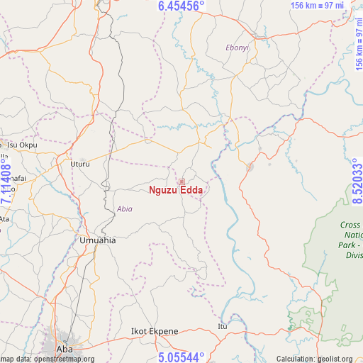
| Upper-left | 6.45456°, | 7.11408° |
| Center: | 5.75543°, | 7.81721° |
| Lower-right: | 5.05544°, | 8.52033° |
| Map W x H: | 155.6×155.6 km | = 96.7×96.7mi |
| max Lat: | 13.7543° ⇑87% North |
| Nguzu Edda: | 5.75543° |
| min Lat: | ⇓13% South 4.31231° |
| min Long | Nguzu Edda | max Long |
| 2.73333° | 7.81721° | 14.46552° |
| W 60.1%⇐ | ⇒39.9% E |
Elevation
Elevation of Nguzu Edda is 184 m = 604 ft, and this is 112.5 m = 369 ft below average elevation for this country.
| Max E: |
1599 m = 5246 ft | 63.9% |
| Avg. | 296.5 m = 973 ft | |
| Nguzu Edda | 184 m = 604 ft | |
Min E: |
2 m = 7 ft | 36.1% |
See also: Nigeria elevation on elevation.city.
Geographical zone
Nguzu Edda is located in North Torrid zone (between Equator and Tropic of Cancer). Distance of Equator is 639.9 km =397.6 mi to South.| Distance of | km | miles | from Nguzu Edda |
|---|---|---|---|
| North Pole | 9367.1 | 5820.4 | to North |
| Arctic Circle | 6761.2 | 4201.2 | to North |
| Tropic Cancer | 1966 | 1221.6 | to North |
| Equator | 639.9 | 397.6 | to South |


Nearby cities:
15 places around Nguzu Edda: (largest is in red/bold)
• Afikpo
20.1 km =12.5 mi,  40°
40°
• Ake-Eze
23.8 km =14.8 mi,  318°
318°
• Akpet Central
34.8 km =21.6 mi,  115°
115°
• Amaigbo
4.4 km =2.7 mi,  31°
31°
• Arochukwu
42 km =26.1 mi,  165°
165°
• Bende
29.9 km =18.6 mi,  222°
222°
• Ebem Ohafia
13.9 km =8.6 mi, 174°
• Isiaka
32.3 km =20.1 mi,  291°
291°
• Itigidi
27.2 km =16.9 mi,  56°
56°
• Mbalano
34.9 km =21.7 mi,  266°
266°
• Ndeaboh
41.4 km =25.7 mi, 318°
• Obiozara
32.7 km =20.3 mi,  351°
351°
• Ohafia-Ifigh
15.7 km =9.8 mi,  182°
182°
• Ugep
29.8 km =18.5 mi,  78°
78°
• Umuahia
43.9 km =27.3 mi,  234°
234°
Sources, notices
• [Note1] Compared only with cities in Nigeria existing in our database
• [Src1] Map data: © OpenStreetMap contributors (CC-BY-SA)
• [Src2] Other city data from geonames.org with taken over terms of usage.
• [Src3] Geographical zone / Annual Mean Temperature by Robert A. Rohde @ Wikipedia
