Ohafia-Ifigh geodata
Ohafia-Ifigh (Abia) is a populated place; located in Nigeria in Africa/Lagos (GMT+1) time zone. With population of 73,355 people, there are 128 cities with bigger population in this country. Compared to other cities in Nigeria, 88.5% of cities are located further ↑North; 59.9% of cities are located further ←West and 74.5% of cities have higher elevation than Ohafia-Ifigh. Note1


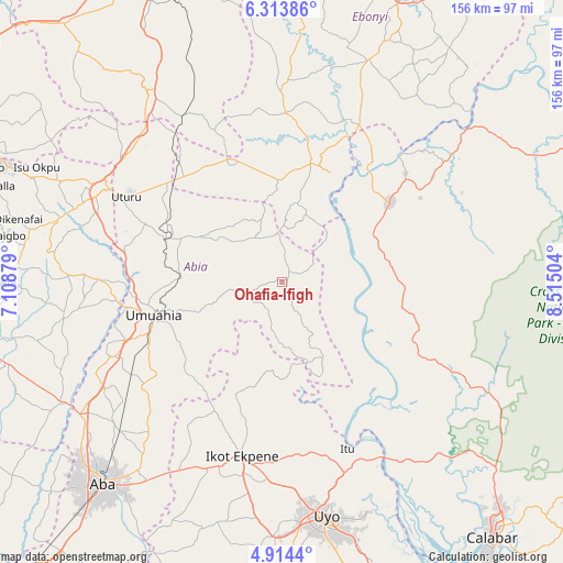
Ohafia-Ifigh GPS coordinates[2]
5° 36' 52.38" North, 7° 48' 42.876" East
| Map corner | latitude | longitude |
|---|---|---|
| Upper-left | 6.31386°, | 7.10879° |
| Center: | 5.61455°, | 7.81191° |
| Lower-right: | 4.9144°, | 8.51504° |
| Map W x H: | 155.6×155.6 km | = 96.7×96.7mi |
| max Lat: | 13.7543° ⇑88.5% North |
| Ohafia-Ifigh: | 5.61455° |
| min Lat: | ⇓11.5% South 4.31231° |
| min Long | Ohafia-Ifigh | max Long |
| 2.73333° | 7.81191° | 14.46552° |
| W 59.9%⇐ | ⇒40.1% E |
Elevation
Elevation of Ohafia-Ifigh is 124 m = 407 ft, and this is 172.5 m = 566 ft below average elevation for this country.
| Max E: |
1599 m = 5246 ft | 74.5% |
| Avg. | 296.5 m = 973 ft | |
| Ohafia-Ifigh | 124 m = 407 ft | |
Min E: |
2 m = 7 ft | 25.5% |
See also: Ohafia-Ifigh elevation on elevation.city.
Geographical zone
Ohafia-Ifigh is located in North Torrid zone (between Equator and Tropic of Cancer). Distance of Equator is 624.3 km =387.9 mi to South.| Distance of | km | miles | from Ohafia-Ifigh |
|---|---|---|---|
| North Pole | 9382.8 | 5830.2 | to North |
| Arctic Circle | 6776.9 | 4211 | to North |
| Tropic Cancer | 1981.6 | 1231.3 | to North |
| Equator | 624.3 | 387.9 | to South |


Nearby cities:
15 places around Ohafia-Ifigh: (largest is in red/bold)
• Afikpo
33.8 km =21 mi,  23°
23°
• Ake-Eze
36.8 km =22.9 mi,  335°
335°
• Akpet Central
32.1 km =19.9 mi,  88°
88°
• Amaigbo
19.6 km =12.2 mi,  8°
8°
• Arochukwu
27.4 km =17 mi,  156°
156°
• Bende
20.7 km =12.9 mi,  252°
252°
• Ebem Ohafia
2.7 km =1.7 mi,  47°
47°
• Ibiaku Ntok Okpo
35.8 km =22.2 mi,  198°
198°
• Isiala Oboro
35.6 km =22.1 mi,  229°
229°
• Itigidi
38.6 km =24 mi,  37°
37°
• Mbalano
36.7 km =22.8 mi,  291°
291°
• Nguzu Edda
15.7 km =9.8 mi,  2°
2°
• Odoro Ikpe
29.3 km =18.2 mi,  193°
193°
• Ugep
36.8 km =22.9 mi, 54°
• Umuahia
36.5 km =22.7 mi, 254°
Sources, notices
• [Note1] Compared only with cities in Nigeria existing in our database
• [Src1] Map data: © OpenStreetMap contributors (CC-BY-SA)
• [Src2] Other city data from geonames.org with taken over terms of usage.
• [Src3] Geographical zone / Annual Mean Temperature by Robert A. Rohde @ Wikipedia
