Bende geodata
Bende (Abia) is a seat of a second-order administrative division; located in Nigeria in Africa/Lagos (GMT+1) time zone. With population of 79,618 people, there are 111 cities with bigger population in this country. Compared to other cities in Nigeria, 89% of cities are located further ↑North; 56.2% of cities are located further ←West and 74.7% of cities have higher elevation than Bende. Note1


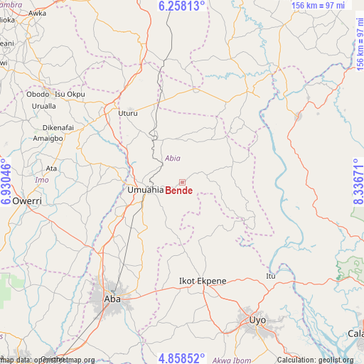
Bende GPS coordinates[2]
5° 33' 31.464" North, 7° 38' 0.924" East
| Map corner | latitude | longitude |
|---|---|---|
| Upper-left | 6.25813°, | 6.93046° |
| Center: | 5.55874°, | 7.63359° |
| Lower-right: | 4.85852°, | 8.33671° |
| Map W x H: | 155.6×155.6 km | = 96.7×96.7mi |
| max Lat: | 13.7543° ⇑89% North |
| Bende: | 5.55874° |
| min Lat: | ⇓11% South 4.31231° |
| min Long | Bende | max Long |
| 2.73333° | 7.63359° | 14.46552° |
| W 56.2%⇐ | ⇒43.8% E |
Elevation
Elevation of Bende is 123 m = 404 ft, and this is 173.5 m = 569 ft below average elevation for this country.
| Max E: |
1599 m = 5246 ft | 74.7% |
| Avg. | 296.5 m = 973 ft | |
| Bende | 123 m = 404 ft | |
Min E: |
2 m = 7 ft | 25.3% |
See also: Bende elevation on elevation.city.
Geographical zone
Bende is located in North Torrid zone (between Equator and Tropic of Cancer). Distance of Equator is 618.1 km =384.1 mi to South.| Distance of | km | miles | from Bende |
|---|---|---|---|
| North Pole | 9389 | 5834.1 | to North |
| Arctic Circle | 6783.1 | 4214.8 | to North |
| Tropic Cancer | 1987.8 | 1235.2 | to North |
| Equator | 618.1 | 384.1 | to South |


Nearby cities:
15 places around Bende: (largest is in red/bold)
• Amaigbo
34.2 km =21.3 mi,  41°
41°
• Arochukwu
36.1 km =22.4 mi,  121°
121°
• Ebem Ohafia
23.2 km =14.4 mi,  69°
69°
• Ibiaku Ntok Okpo
29.1 km =18.1 mi,  162°
162°
• Isiaka
35.1 km =21.8 mi,  344°
344°
• Isiala Oboro
18.4 km =11.4 mi,  203°
203°
• Isinweke
32.1 km =19.9 mi,  282°
282°
• Itu
35.1 km =21.8 mi,  252°
252°
• Mbalano
24.3 km =15.1 mi,  323°
323°
• Nguzu Edda
29.9 km =18.6 mi, 42°
• Nto Edino
34.2 km =21.3 mi,  190°
190°
• Odoro Ikpe
25.8 km =16 mi,  149°
149°
• Ohafia-Ifigh
20.7 km =12.9 mi, 72°
• Okpuala-Ngwa
35.3 km =21.9 mi,  230°
230°
• Umuahia
15.8 km =9.8 mi,  256°
256°
Sources, notices
• [Note1] Compared only with cities in Nigeria existing in our database
• [Src1] Map data: © OpenStreetMap contributors (CC-BY-SA)
• [Src2] Other city data from geonames.org with taken over terms of usage.
• [Src3] Geographical zone / Annual Mean Temperature by Robert A. Rohde @ Wikipedia
