Abocho geodata
Abocho (Kogi) is a populated place; located in Nigeria in Africa/Lagos (GMT+1) time zone. With population of 6,801 people, there are 424 cities with bigger population in this country. Compared to other cities in Nigeria, 59.8% of cities are located further ↑North; 57.3% of cities are located further →East and 71.7% of cities have lower elevation than Abocho. Note1


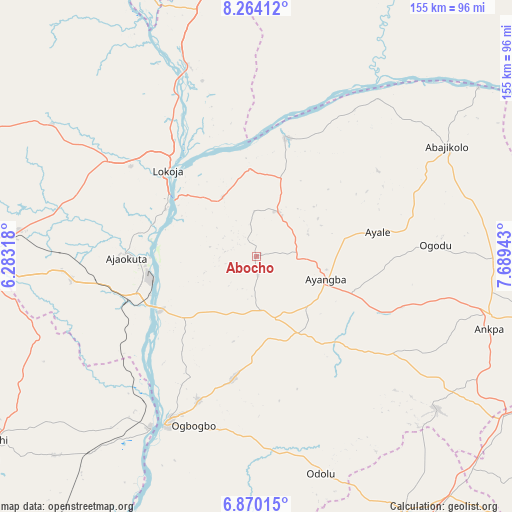
Abocho GPS coordinates[2]
7° 34' 3.72" North, 6° 59' 10.68" East
| Map corner | latitude | longitude |
|---|---|---|
| Upper-left | 8.26412°, | 6.28318° |
| Center: | 7.5677°, | 6.9863° |
| Lower-right: | 6.87015°, | 7.68943° |
| Map W x H: | 155×155 km | = 96.3×96.3mi |
| max Lat: | 13.7543° ⇑59.8% North |
| Abocho: | 7.5677° |
| min Lat: | ⇓40.2% South 4.31231° |
| min Long | Abocho | max Long |
| 2.73333° | 6.9863° | 14.46552° |
| W 42.7%⇐ | ⇒57.3% E |
Elevation
Elevation of Abocho is 412 m = 1352 ft, and this is 115.5 m = 379 ft above average elevation for this country.
| Max E: |
1599 m = 5246 ft | 28.3% |
| Abocho | 412 m 1352 ft | |
| Avg. | 296.5 m = 973 ft | |
Min E: |
2 m = 7 ft | 71.7% |
See also: Nigeria elevation on elevation.city.
Geographical zone
Abocho is located in North Torrid zone (between Equator and Tropic of Cancer). Distance of Equator is 841.4 km =522.8 mi to South.| Distance of | km | miles | from Abocho |
|---|---|---|---|
| North Pole | 9165.6 | 5695.2 | to North |
| Arctic Circle | 6559.7 | 4076 | to North |
| Tropic Cancer | 1764.5 | 1096.4 | to North |
| Equator | 841.4 | 522.8 | to South |


Nearby cities:
15 places around Abocho: (largest is in red/bold)
• Abejukolo
66.6 km =41.4 mi,  59°
59°
• Adogo
56.2 km =34.9 mi,  263°
263°
• Adoru
68.5 km =42.6 mi,  163°
163°
• Agenebode
60.7 km =37.7 mi,  212°
212°
• Ajaka
47.2 km =29.3 mi,  202°
202°
• Ajaokuta
36.5 km =22.7 mi,  269°
269°
• Ankpa
73.5 km =45.7 mi,  104°
104°
• Dekina
15 km =9.3 mi,  25°
25°
• Ete
74 km =46 mi,  135°
135°
• Icheu
28.2 km =17.5 mi,  303°
303°
• Idah
57.4 km =35.7 mi, 208°
• Koton-Karfe
61.8 km =38.4 mi,  340°
340°
• Lokoja
37.2 km =23.1 mi,  313°
313°
• Oguma
37.5 km =23.3 mi,  12°
12°
• Ugwolawo
37.5 km =23.3 mi,  190°
190°
Sources, notices
• [Note1] Compared only with cities in Nigeria existing in our database
• [Src1] Map data: © OpenStreetMap contributors (CC-BY-SA)
• [Src2] Other city data from geonames.org with taken over terms of usage.
• [Src3] Geographical zone / Annual Mean Temperature by Robert A. Rohde @ Wikipedia
