Ajaokuta geodata
Ajaokuta (Kogi) is a populated place; located in Nigeria in Africa/Lagos (GMT+1) time zone. With population of 15,144 people, there are 240 cities with bigger population in this country. Compared to other cities in Nigeria, 60% of cities are located further ↑North; 62.9% of cities are located further →East and 86.5% of cities have higher elevation than Ajaokuta. Note1


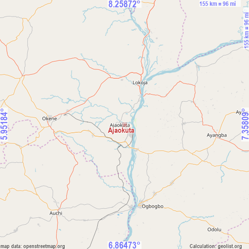
Ajaokuta GPS coordinates[2]
7° 33' 44.244" North, 6° 39' 17.892" East
| Map corner | latitude | longitude |
|---|---|---|
| Upper-left | 8.25872°, | 5.95184° |
| Center: | 7.56229°, | 6.65497° |
| Lower-right: | 6.86473°, | 7.35809° |
| Map W x H: | 155×155 km | = 96.3×96.3mi |
| max Lat: | 13.7543° ⇑60% North |
| Ajaokuta: | 7.56229° |
| min Lat: | ⇓40% South 4.31231° |
| min Long | Ajaokuta | max Long |
| 2.73333° | 6.65497° | 14.46552° |
| W 37.1%⇐ | ⇒62.9% E |
Elevation
Elevation of Ajaokuta is 52 m = 171 ft, and this is 244.5 m = 802 ft below average elevation for this country.
| Max E: |
1599 m = 5246 ft | 86.5% |
| Avg. | 296.5 m = 973 ft | |
| Ajaokuta | 52 m = 171 ft | |
Min E: |
2 m = 7 ft | 13.5% |
See also: Nigeria elevation on elevation.city.
Geographical zone
Ajaokuta is located in North Torrid zone (between Equator and Tropic of Cancer). Distance of Equator is 840.8 km =522.4 mi to South.| Distance of | km | miles | from Ajaokuta |
|---|---|---|---|
| North Pole | 9166.2 | 5695.6 | to North |
| Arctic Circle | 6560.3 | 4076.4 | to North |
| Tropic Cancer | 1765.1 | 1096.8 | to North |
| Equator | 840.8 | 522.4 | to South |


Nearby cities:
15 places around Ajaokuta: (largest is in red/bold)
• Abocho
36.5 km =22.7 mi,  89°
89°
• Adogo
20.2 km =12.6 mi,  253°
253°
• Agenebode
51 km =31.7 mi,  175°
175°
• Ajaka
47.1 km =29.3 mi,  156°
156°
• Akpafa
56.6 km =35.2 mi,  259°
259°
• Dekina
45.1 km =28 mi,  71°
71°
• Fugar
55.2 km =34.3 mi,  198°
198°
• Icheu
20.6 km =12.8 mi,  38°
38°
• Idah
50.8 km =31.6 mi,  169°
169°
• Lokoja
27.7 km =17.2 mi,  19°
19°
• Obangede
50.6 km =31.4 mi,  277°
277°
• Ogaminana
48.3 km =30 mi,  274°
274°
• Oguma
58.3 km =36.2 mi,  50°
50°
• Okene
46.2 km =28.7 mi, 268°
• Ugwolawo
46.7 km =29 mi,  140°
140°
Sources, notices
• [Note1] Compared only with cities in Nigeria existing in our database
• [Src1] Map data: © OpenStreetMap contributors (CC-BY-SA)
• [Src2] Other city data from geonames.org with taken over terms of usage.
• [Src3] Geographical zone / Annual Mean Temperature by Robert A. Rohde @ Wikipedia
