Icheu geodata
Icheu (Kogi) is a populated place; located in Nigeria in Africa/Lagos (GMT+1) time zone. With population of 14,704 people, there are 244 cities with bigger population in this country. Compared to other cities in Nigeria, 57.7% of cities are located further ↑North; 61.3% of cities are located further →East and 87.6% of cities have higher elevation than Icheu. Note1


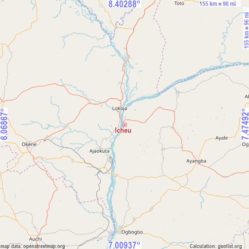
Icheu GPS coordinates[2]
7° 42' 24.12" North, 6° 46' 18.48" East
| Map corner | latitude | longitude |
|---|---|---|
| Upper-left | 8.40288°, | 6.06867° |
| Center: | 7.7067°, | 6.7718° |
| Lower-right: | 7.00937°, | 7.47492° |
| Map W x H: | 154.9×154.9 km | = 96.3×96.3mi |
| max Lat: | 13.7543° ⇑57.7% North |
| Icheu: | 7.7067° |
| min Lat: | ⇓42.3% South 4.31231° |
| min Long | Icheu | max Long |
| 2.73333° | 6.7718° | 14.46552° |
| W 38.7%⇐ | ⇒61.3% E |
Elevation
Elevation of Icheu is 47 m = 154 ft, and this is 249.5 m = 819 ft below average elevation for this country.
| Max E: |
1599 m = 5246 ft | 87.6% |
| Avg. | 296.5 m = 973 ft | |
| Icheu | 47 m = 154 ft | |
Min E: |
2 m = 7 ft | 12.4% |
See also: Nigeria elevation on elevation.city.
Geographical zone
Icheu is located in North Torrid zone (between Equator and Tropic of Cancer). Distance of Equator is 856.9 km =532.5 mi to South.| Distance of | km | miles | from Icheu |
|---|---|---|---|
| North Pole | 9150.2 | 5685.7 | to North |
| Arctic Circle | 6544.3 | 4066.4 | to North |
| Tropic Cancer | 1749 | 1086.8 | to North |
| Equator | 856.9 | 532.5 | to South |


Nearby cities:
15 places around Icheu: (largest is in red/bold)
• Abocho
28.2 km =17.5 mi,  123°
123°
• Adogo
38.9 km =24.2 mi,  235°
235°
• Agenebode
67.4 km =41.9 mi,  187°
187°
• Ajaka
59.5 km =37 mi,  174°
174°
• Ajaokuta
20.6 km =12.8 mi,  218°
218°
• Akpafa
73.4 km =45.6 mi,  249°
249°
• Dekina
30 km =18.6 mi,  93°
93°
• Idah
66.1 km =41.1 mi,  183°
183°
• Koton-Karfe
42.8 km =26.6 mi,  3°
3°
• Lokoja
10.6 km =6.6 mi,  341°
341°
• Obangede
63.8 km =39.6 mi,  261°
261°
• Ogaminana
62.3 km =38.7 mi, 258°
• Oguma
38.3 km =23.8 mi,  56°
56°
• Okene
61.5 km =38.2 mi, 253°
• Ugwolawo
54.9 km =34.1 mi,  162°
162°
Sources, notices
• [Note1] Compared only with cities in Nigeria existing in our database
• [Src1] Map data: © OpenStreetMap contributors (CC-BY-SA)
• [Src2] Other city data from geonames.org with taken over terms of usage.
• [Src3] Geographical zone / Annual Mean Temperature by Robert A. Rohde @ Wikipedia
