Dekina geodata
Dekina (Kogi) is a seat of a second-order administrative division; located in Nigeria in Africa/Lagos (GMT+1) time zone. With population of 11,067 people, there are 319 cities with bigger population in this country. Compared to other cities in Nigeria, 57.9% of cities are located further ↑North; 55.5% of cities are located further →East and 71% of cities have higher elevation than Dekina. Note1


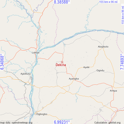
Dekina GPS coordinates[2]
7° 41' 22.812" North, 7° 2' 37.68" East
| Map corner | latitude | longitude |
|---|---|---|
| Upper-left | 8.38588°, | 6.34068° |
| Center: | 7.68967°, | 7.0438° |
| Lower-right: | 6.99231°, | 7.74693° |
| Map W x H: | 155×155 km | = 96.3×96.3mi |
| max Lat: | 13.7543° ⇑57.9% North |
| Dekina: | 7.68967° |
| min Lat: | ⇓42.1% South 4.31231° |
| min Long | Dekina | max Long |
| 2.73333° | 7.0438° | 14.46552° |
| W 44.5%⇐ | ⇒55.5% E |
Elevation
Elevation of Dekina is 141 m = 463 ft, and this is 155.5 m = 510 ft below average elevation for this country.
| Max E: |
1599 m = 5246 ft | 71% |
| Avg. | 296.5 m = 973 ft | |
| Dekina | 141 m = 463 ft | |
Min E: |
2 m = 7 ft | 29% |
See also: Nigeria elevation on elevation.city.
Geographical zone
Dekina is located in North Torrid zone (between Equator and Tropic of Cancer). Distance of Equator is 855 km =531.3 mi to South.| Distance of | km | miles | from Dekina |
|---|---|---|---|
| North Pole | 9152.1 | 5686.8 | to North |
| Arctic Circle | 6546.2 | 4067.6 | to North |
| Tropic Cancer | 1750.9 | 1088 | to North |
| Equator | 855 | 531.3 | to South |


Nearby cities:
15 places around Dekina: (largest is in red/bold)
• Abejukolo
55 km =34.2 mi,  68°
68°
• Abocho
15 km =9.3 mi,  205°
205°
• Adogo
65.3 km =40.6 mi,  252°
252°
• Agenebode
75.6 km =47 mi, 210°
• Ajaka
62.2 km =38.6 mi,  202°
202°
• Ajaokuta
45.1 km =28 mi, 251°
• Ankpa
72.3 km =44.9 mi,  116°
116°
• Bugana
68.7 km =42.7 mi,  59°
59°
• Icheu
30 km =18.6 mi,  273°
273°
• Idah
72.4 km =45 mi, 207°
• Koton-Karfe
52.2 km =32.4 mi,  328°
328°
• Lokoja
35.5 km =22.1 mi,  289°
289°
• Oguma
23.1 km =14.4 mi,  5°
5°
• Okpo
77.5 km =48.2 mi,  132°
132°
• Ugwolawo
52.1 km =32.4 mi,  194°
194°
Sources, notices
• [Note1] Compared only with cities in Nigeria existing in our database
• [Src1] Map data: © OpenStreetMap contributors (CC-BY-SA)
• [Src2] Other city data from geonames.org with taken over terms of usage.
• [Src3] Geographical zone / Annual Mean Temperature by Robert A. Rohde @ Wikipedia
