Konkwesso geodata
Konkwesso (Niger) is a populated place; located in Nigeria in Africa/Lagos (GMT+1) time zone. With population of 7,687 people, there are 392 cities with bigger population in this country. Compared to other cities in Nigeria, 71.6% of cities are located further ↓South; 91.3% of cities are located further →East and 52.8% of cities have higher elevation than Konkwesso. Note1


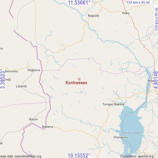
Konkwesso GPS coordinates[2]
10° 50' 48.696" North, 4° 5' 54.06" East
| Map corner | latitude | longitude |
|---|---|---|
| Upper-left | 11.53661°, | 3.39523° |
| Center: | 10.84686°, | 4.09835° |
| Lower-right: | 10.15552°, | 4.80148° |
| Map W x H: | 153.6×153.6 km | = 95.4×95.4mi |
| max Lat: | 13.7543° ⇑28.4% North |
| Konkwesso: | 10.84686° |
| min Lat: | ⇓71.6% South 4.31231° |
| min Long | Konkwesso | max Long |
| 2.73333° | 4.09835° | 14.46552° |
| W 8.7%⇐ | ⇒91.3% E |
Elevation
Elevation of Konkwesso is 265 m = 869 ft, and this is 31.5 m = 103 ft below average elevation for this country.
| Max E: |
1599 m = 5246 ft | 52.8% |
| Avg. | 296.5 m = 973 ft | |
| Konkwesso | 265 m = 869 ft | |
Min E: |
2 m = 7 ft | 47.2% |
See also: Nigeria elevation on elevation.city.
Geographical zone
Konkwesso is located in North Torrid zone (between Equator and Tropic of Cancer). Distance of Equator is 1206.1 km =749.4 mi to South.| Distance of | km | miles | from Konkwesso |
|---|---|---|---|
| North Pole | 8801 | 5468.7 | to North |
| Arctic Circle | 6195.1 | 3849.5 | to North |
| Tropic Cancer | 1399.9 | 869.9 | to North |
| Equator | 1206.1 | 749.4 | to South |


Nearby cities:
15 places around Konkwesso: (largest is in red/bold)
• Agwara
55 km =34.2 mi,  106°
106°
• Auna
100.2 km =62.3 mi,  137°
137°
• Babana
55.8 km =34.7 mi,  213°
213°
• Bagudo
63.4 km =39.4 mi,  12°
12°
• Besse
59.1 km =36.7 mi,  37°
37°
• Bin Yauri
78.2 km =48.6 mi,  95°
95°
• Dakingari
89.2 km =55.4 mi,  357°
357°
• Duku
98.3 km =61.1 mi,  63°
63°
• Kende
76.9 km =47.8 mi, 13°
• Nasko
95.8 km =59.5 mi, 114°
• New Shagunnu
69.4 km =43.1 mi, 144°
• Shanga
66.5 km =41.3 mi,  52°
52°
• Wara
89.5 km =55.6 mi, 140°
• Wawa
110.7 km =68.8 mi,  161°
161°
• Yelwa
70.4 km =43.7 mi,  91°
91°
Sources, notices
• [Note1] Compared only with cities in Nigeria existing in our database
• [Src1] Map data: © OpenStreetMap contributors (CC-BY-SA)
• [Src2] Other city data from geonames.org with taken over terms of usage.
• [Src3] Geographical zone / Annual Mean Temperature by Robert A. Rohde @ Wikipedia
