Koton-Karfe geodata
Koton-Karfe (Kogi) is a seat of a second-order administrative division; located in Nigeria in Africa/Lagos (GMT+1) time zone. With population of 10,709 people, there are 324 cities with bigger population in this country. Compared to other cities in Nigeria, 52.2% of cities are located further ↑North; 60.6% of cities are located further →East and 86.9% of cities have higher elevation than Koton-Karfe. Note1


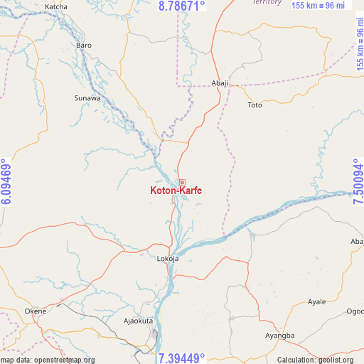
Koton-Karfe GPS coordinates[2]
8° 5' 28.32" North, 6° 47' 52.152" East
| Map corner | latitude | longitude |
|---|---|---|
| Upper-left | 8.78671°, | 6.09469° |
| Center: | 8.0912°, | 6.79782° |
| Lower-right: | 7.39449°, | 7.50094° |
| Map W x H: | 154.8×154.8 km | = 96.2×96.2mi |
| max Lat: | 13.7543° ⇑52.2% North |
| Koton-Karfe: | 8.0912° |
| min Lat: | ⇓47.8% South 4.31231° |
| min Long | Koton-Karfe | max Long |
| 2.73333° | 6.79782° | 14.46552° |
| W 39.4%⇐ | ⇒60.6% E |
Elevation
Elevation of Koton-Karfe is 51 m = 167 ft, and this is 245.5 m = 805 ft below average elevation for this country.
| Max E: |
1599 m = 5246 ft | 86.9% |
| Avg. | 296.5 m = 973 ft | |
| Koton-Karfe | 51 m = 167 ft | |
Min E: |
2 m = 7 ft | 13.1% |
See also: Nigeria elevation on elevation.city.
Geographical zone
Koton-Karfe is located in North Torrid zone (between Equator and Tropic of Cancer). Distance of Equator is 899.7 km =559 mi to South.| Distance of | km | miles | from Koton-Karfe |
|---|---|---|---|
| North Pole | 9107.4 | 5659.1 | to North |
| Arctic Circle | 6501.5 | 4039.8 | to North |
| Tropic Cancer | 1706.3 | 1060.2 | to North |
| Equator | 899.7 | 559 | to South |


Nearby cities:
15 places around Koton-Karfe: (largest is in red/bold)
• Abaji
45.5 km =28.3 mi,  20°
20°
• Abejukolo
82.2 km =51.1 mi,  107°
107°
• Abocho
61.8 km =38.4 mi,  160°
160°
• Adogo
73.5 km =45.7 mi,  208°
208°
• Ajaokuta
60.9 km =37.8 mi,  194°
194°
• Baro
71.7 km =44.6 mi,  324°
324°
• Buga
74.5 km =46.3 mi,  53°
53°
• Dekina
52.2 km =32.4 mi,  148°
148°
• Icheu
42.8 km =26.6 mi,  183°
183°
• Kabba
84.8 km =52.7 mi,  249°
249°
• Lokoja
33.3 km =20.7 mi, 190°
• Obangede
84.2 km =52.3 mi,  231°
231°
• Ogaminana
84.5 km =52.5 mi, 229°
• Oguma
36.3 km =22.6 mi,  126°
126°
• Toto
45.1 km =28 mi,  43°
43°
Sources, notices
• [Note1] Compared only with cities in Nigeria existing in our database
• [Src1] Map data: © OpenStreetMap contributors (CC-BY-SA)
• [Src2] Other city data from geonames.org with taken over terms of usage.
• [Src3] Geographical zone / Annual Mean Temperature by Robert A. Rohde @ Wikipedia
