Kafanchan geodata
Kafanchan (Kaduna) is a seat of a second-order administrative division; located in Nigeria in Africa/Lagos (GMT+1) time zone. With population of 79,522 people, there are 113 cities with bigger population in this country. Compared to other cities in Nigeria, 60.2% of cities are located further ↓South; 68.7% of cities are located further ←West and 97.2% of cities have lower elevation than Kafanchan. Note1


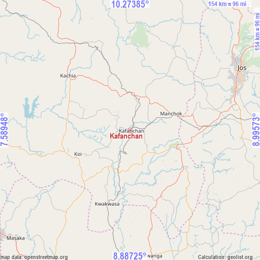
Kafanchan GPS coordinates[2]
9° 34' 52.536" North, 8° 17' 33.36" East
| Map corner | latitude | longitude |
|---|---|---|
| Upper-left | 10.27385°, | 7.58948° |
| Center: | 9.58126°, | 8.2926° |
| Lower-right: | 8.88725°, | 8.99573° |
| Map W x H: | 154.2×154.2 km | = 95.8×95.8mi |
| max Lat: | 13.7543° ⇑39.8% North |
| Kafanchan: | 9.58126° |
| min Lat: | ⇓60.2% South 4.31231° |
| min Long | Kafanchan | max Long |
| 2.73333° | 8.2926° | 14.46552° |
| W 68.7%⇐ | ⇒31.3% E |
Elevation
Elevation of Kafanchan is 733 m = 2405 ft, and this is 436.5 m = 1432 ft above average elevation for this country.
| Max E: |
1599 m = 5246 ft | 2.8% |
| Kafanchan | 733 m 2405 ft | |
| Avg. | 296.5 m = 973 ft | |
Min E: |
2 m = 7 ft | 97.2% |
See also: Kafanchan elevation on elevation.city.
Geographical zone
Kafanchan is located in North Torrid zone (between Equator and Tropic of Cancer). Distance of Equator is 1065.3 km =661.9 mi to South.| Distance of | km | miles | from Kafanchan |
|---|---|---|---|
| North Pole | 8941.7 | 5556.1 | to North |
| Arctic Circle | 6335.8 | 3936.9 | to North |
| Tropic Cancer | 1540.6 | 957.3 | to North |
| Equator | 1065.3 | 661.9 | to South |


Nearby cities:
15 places around Kafanchan: (largest is in red/bold)
• Akwanga
75.6 km =47 mi,  170°
170°
• Barkin Ladi
66 km =41 mi,  94°
94°
• Bassa
63.4 km =39.4 mi,  50°
50°
• Bukuru
66.9 km =41.6 mi,  69°
69°
• Gwantu
43.2 km =26.8 mi,  155°
155°
• Jos
76.2 km =47.3 mi,  59°
59°
• Kachia
49.3 km =30.6 mi,  311°
311°
• Kagarko
66 km =41 mi,  261°
261°
• Kagoro
11.1 km =6.9 mi, 74°
• Kaura
20.6 km =12.8 mi, 61°
• Kwoi
34.2 km =21.3 mi,  246°
246°
• Riyom
51.3 km =31.9 mi,  83°
83°
• Vom
57.1 km =35.5 mi, 73°
• Wamba
78.9 km =49 mi,  154°
154°
• Zonkwa
22.6 km =14 mi,  359°
359°
Sources, notices
• [Note1] Compared only with cities in Nigeria existing in our database
• [Src1] Map data: © OpenStreetMap contributors (CC-BY-SA)
• [Src2] Other city data from geonames.org with taken over terms of usage.
• [Src3] Geographical zone / Annual Mean Temperature by Robert A. Rohde @ Wikipedia
