Bluefields geodata
Bluefields (South Caribbean Coast) is a seat of a first-order administrative division; located in Nicaragua in America/Managua (GMT-6) time zone. With population of 44,373 people, there are 13 cities with bigger population in this country. Compared to other cities in Nicaragua, 72.5% of cities are located further ↑North; 95.8% of cities are located further ←West and 92.2% of cities have higher elevation than Bluefields. Note1


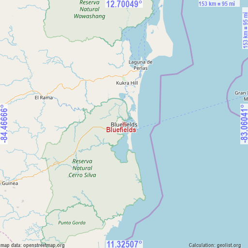
Bluefields GPS coordinates[2]
12° 0' 49.176" North, 83° 45' 48.708" West
| Map corner | latitude | longitude |
|---|---|---|
| Upper-left | 12.70049°, | -84.46666° |
| Center: | 12.01366°, | -83.76353° |
| Lower-right: | 11.32507°, | -83.06041° |
| Map W x H: | 152.9×152.9 km | = 95×95mi |
| max Lat: | 14.74189° ⇑72.5% North |
| Bluefields: | 12.01366° |
| min Lat: | ⇓27.5% South 10.94684° |
| min Long | Bluefields | max Long |
| -87.4516° | -83.76353° | -83.06145° |
| W 95.8%⇐ | ⇒4.2% E |
Elevation
Elevation of Bluefields is 16 m = 52 ft, and this is 321.2 m = 1054 ft below average elevation for this country.
| Max E: |
1288 m = 4226 ft | 92.2% |
| Avg. | 337.2 m = 1106 ft | |
| Bluefields | 16 m = 52 ft | |
Min E: |
1 m = 3 ft | 7.8% |
See also: Bluefields elevation on elevation.city.
Geographical zone
Bluefields is located in North Torrid zone (between Equator and Tropic of Cancer). Distance of this Northern Tropic circle is 1270.1 km =789.2 mi to North.| Distance of | km | miles | from Bluefields |
|---|---|---|---|
| North Pole | 8671.3 | 5388.1 | to North |
| Arctic Circle | 6065.4 | 3768.9 | to North |
| Tropic Cancer | 1270.1 | 789.2 | to North |
| Equator | 1335.8 | 830 | to South |


Nearby cities:
15 places around Bluefields: (largest is in red/bold)
• Boca de Sábalos
131.7 km =81.8 mi,  215°
215°
• Corn Island
78.4 km =48.7 mi,  76°
76°
• El Almendro
108.8 km =67.6 mi,  249°
249°
• El Ayote
126.4 km =78.5 mi,  295°
295°
• El Castillo de La Concepción
130.5 km =81.1 mi,  211°
211°
• El Coral
96.8 km =60.1 mi,  263°
263°
• El Rama
52.2 km =32.4 mi,  288°
288°
• El Tortuguero
101.5 km =63.1 mi,  332°
332°
• Greytown
118.7 km =73.8 mi,  178°
178°
• Karawala
104 km =64.6 mi,  11°
11°
• Kukrahill
25.4 km =15.8 mi,  4°
4°
• La Cruz de Río Grande
130.5 km =81.1 mi,  339°
339°
• Laguna de Perlas
38 km =23.6 mi,  15°
15°
• Muelle de los Bueyes
84.1 km =52.3 mi,  274°
274°
• Nueva Guinea
83.6 km =51.9 mi,  244°
244°
Sources, notices
• [Note1] Compared only with cities in Nicaragua existing in our database
• [Src1] Map data: © OpenStreetMap contributors (CC-BY-SA)
• [Src2] Other city data from geonames.org with taken over terms of usage.
• [Src3] Geographical zone / Annual Mean Temperature by Robert A. Rohde @ Wikipedia
