Laguna de Perlas geodata
Laguna de Perlas (South Caribbean Coast) is a seat of a second-order administrative division; located in Nicaragua in America/Managua (GMT-6) time zone. With population of 6,809 people, there are 62 cities with bigger population in this country. Compared to other cities in Nicaragua, 59.3% of cities are located further ↑North; 97.6% of cities are located further ←West and 95.8% of cities have higher elevation than Laguna de Perlas. Note1


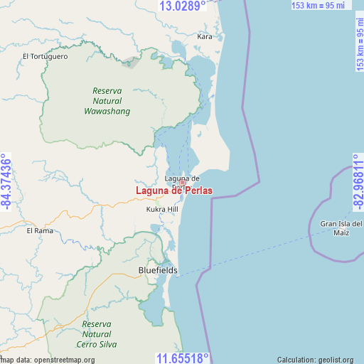
Laguna de Perlas GPS coordinates[2]
12° 20' 34.584" North, 83° 40' 16.428" West
| Map corner | latitude | longitude |
|---|---|---|
| Upper-left | 13.0289°, | -84.37436° |
| Center: | 12.34294°, | -83.67123° |
| Lower-right: | 11.65518°, | -82.96811° |
| Map W x H: | 152.7×152.7 km | = 94.9×94.9mi |
| max Lat: | 14.74189° ⇑59.3% North |
| Laguna de Perlas: | 12.34294° |
| min Lat: | ⇓40.7% South 10.94684° |
| min Long | Laguna de Perla | max Long |
| -87.4516° | -83.67123° | -83.06145° |
| W 97.6%⇐ | ⇒2.4% E |
Elevation
Elevation of Laguna de Perlas is 10 m = 33 ft, and this is 327.2 m = 1073 ft below average elevation for this country.
| Max E: |
1288 m = 4226 ft | 95.8% |
| Avg. | 337.2 m = 1106 ft | |
| Laguna de Perlas | 10 m = 33 ft | |
Min E: |
1 m = 3 ft | 4.2% |
See also: Nicaragua elevation on elevation.city.
Geographical zone
Laguna de Perlas is located in North Torrid zone (between Equator and Tropic of Cancer). Distance of this Northern Tropic circle is 1233.5 km =766.5 mi to North.| Distance of | km | miles | from Laguna de Perlas |
|---|---|---|---|
| North Pole | 8634.7 | 5365.4 | to North |
| Arctic Circle | 6028.8 | 3746.1 | to North |
| Tropic Cancer | 1233.5 | 766.5 | to North |
| Equator | 1372.4 | 852.8 | to South |


Nearby cities:
15 places around Laguna de Perlas: (largest is in red/bold)
• Bluefields
38 km =23.6 mi,  195°
195°
• Corn Island
68.8 km =42.8 mi,  105°
105°
• El Almendro
134.3 km =83.5 mi,  236°
236°
• El Ayote
125.4 km =77.9 mi,  277°
277°
• El Coral
116.3 km =72.3 mi,  246°
246°
• El Rama
63 km =39.1 mi, 251°
• El Tortuguero
78 km =48.5 mi,  313°
313°
• Karawala
66.1 km =41.1 mi,  8°
8°
• Kukrahill
13.9 km =8.6 mi,  215°
215°
• La Cruz de Río Grande
102.2 km =63.5 mi,  326°
326°
• Muelle de los Bueyes
98.7 km =61.3 mi, 252°
• Nueva Guinea
112.2 km =69.7 mi,  229°
229°
• Prinzapolka
118.9 km =73.9 mi, 5°
• Santo Domingo
153.5 km =95.4 mi,  266°
266°
• Villa Sandino
147.4 km =91.6 mi,  257°
257°
Sources, notices
• [Note1] Compared only with cities in Nicaragua existing in our database
• [Src1] Map data: © OpenStreetMap contributors (CC-BY-SA)
• [Src2] Other city data from geonames.org with taken over terms of usage.
• [Src3] Geographical zone / Annual Mean Temperature by Robert A. Rohde @ Wikipedia
