Kukrahill geodata
Kukrahill (South Caribbean Coast) is a seat of a second-order administrative division; located in Nicaragua in America/Managua (GMT-6) time zone. In our database, there are 137 cities with bigger population. Compared to other cities in Nicaragua, 62.9% of cities are located further ↑North; 96.4% of cities are located further ←West and 91% of cities have higher elevation than Kukrahill. Note1


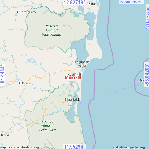
Kukrahill GPS coordinates[2]
12° 14' 27.456" North, 83° 44' 42.612" West
| Map corner | latitude | longitude |
|---|---|---|
| Upper-left | 12.92719°, | -84.4483° |
| Center: | 12.24096°, | -83.74517° |
| Lower-right: | 11.55294°, | -83.04205° |
| Map W x H: | 152.8×152.8 km | = 94.9×94.9mi |
| max Lat: | 14.74189° ⇑62.9% North |
| Kukrahill: | 12.24096° |
| min Lat: | ⇓37.1% South 10.94684° |
| min Long | Kukrahill | max Long |
| -87.4516° | -83.74517° | -83.06145° |
| W 96.4%⇐ | ⇒3.6% E |
Elevation
Elevation of Kukrahill is 33 m = 108 ft, and this is 304.2 m = 998 ft below average elevation for this country.
| Max E: |
1288 m = 4226 ft | 91% |
| Avg. | 337.2 m = 1106 ft | |
| Kukrahill | 33 m = 108 ft | |
Min E: |
1 m = 3 ft | 9% |
See also: Nicaragua elevation on elevation.city.
Geographical zone
Kukrahill is located in North Torrid zone (between Equator and Tropic of Cancer). Distance of this Northern Tropic circle is 1244.9 km =773.5 mi to North.| Distance of | km | miles | from Kukrahill |
|---|---|---|---|
| North Pole | 8646 | 5372.4 | to North |
| Arctic Circle | 6040.1 | 3753.1 | to North |
| Tropic Cancer | 1244.9 | 773.5 | to North |
| Equator | 1361.1 | 845.7 | to South |


Nearby cities:
15 places around Kukrahill: (largest is in red/bold)
• Bluefields
25.4 km =15.8 mi,  184°
184°
• Corn Island
74.7 km =46.4 mi,  95°
95°
• El Almendro
121.5 km =75.5 mi,  239°
239°
• El Ayote
119.7 km =74.4 mi,  283°
283°
• El Coral
104.6 km =65 mi,  249°
249°
• El Rama
52.3 km =32.5 mi,  260°
260°
• El Tortuguero
81.1 km =50.4 mi,  322°
322°
• Greytown
143.9 km =89.4 mi, 179°
• Karawala
78.8 km =49 mi,  13°
13°
• La Cruz de Río Grande
108.1 km =67.2 mi,  333°
333°
• Laguna de Perlas
13.9 km =8.6 mi,  35°
35°
• Muelle de los Bueyes
87.9 km =54.6 mi, 257°
• Nueva Guinea
98.8 km =61.4 mi,  231°
231°
• Prinzapolka
131.1 km =81.5 mi, 8°
• Villa Sandino
137.4 km =85.4 mi, 261°
Sources, notices
• [Note1] Compared only with cities in Nicaragua existing in our database
• [Src1] Map data: © OpenStreetMap contributors (CC-BY-SA)
• [Src2] Other city data from geonames.org with taken over terms of usage.
• [Src3] Geographical zone / Annual Mean Temperature by Robert A. Rohde @ Wikipedia
