Corn Island geodata
Corn Island (South Caribbean Coast) is a seat of a second-order administrative division; located in Nicaragua in America/Managua (GMT-6) time zone. With population of 8,011 people, there are 48 cities with bigger population in this country. Compared to other cities in Nicaragua, 65.9% of cities are located further ↑North; 100% of cities are located further ←West and 65.9% of cities have higher elevation than Corn Island. Note1


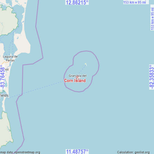
Corn Island GPS coordinates[2]
12° 10' 32.7" North, 83° 3' 41.22" West
| Map corner | latitude | longitude |
|---|---|---|
| Upper-left | 12.86215°, | -83.76458° |
| Center: | 12.17575°, | -83.06145° |
| Lower-right: | 11.48757°, | -82.35833° |
| Map W x H: | 152.8×152.8 km | = 94.9×94.9mi |
| max Lat: | 14.74189° ⇑65.9% North |
| Corn Island: | 12.17575° |
| min Lat: | ⇓34.1% South 10.94684° |
| min Long | Corn Island | max Long |
| -87.4516° | -83.06145° | -83.06145° |
| W 100%⇐ | ⇒0% E |
Elevation
Elevation of Corn Island is 113 m = 371 ft, and this is 224.2 m = 736 ft below average elevation for this country.
| Max E: |
1288 m = 4226 ft | 65.9% |
| Avg. | 337.2 m = 1106 ft | |
| Corn Island | 113 m = 371 ft | |
Min E: |
1 m = 3 ft | 34.1% |
See also: Nicaragua elevation on elevation.city.
Geographical zone
Corn Island is located in North Torrid zone (between Equator and Tropic of Cancer). Distance of this Northern Tropic circle is 1252.1 km =778 mi to North.| Distance of | km | miles | from Corn Island |
|---|---|---|---|
| North Pole | 8653.2 | 5376.8 | to North |
| Arctic Circle | 6047.4 | 3757.7 | to North |
| Tropic Cancer | 1252.1 | 778 | to North |
| Equator | 1353.8 | 841.2 | to South |


Nearby cities:
15 places around Corn Island: (largest is in red/bold)
• Bluefields
78.4 km =48.7 mi,  256°
256°
• El Almendro
186.9 km =116.1 mi,  252°
252°
• El Ayote
193.9 km =120.5 mi,  280°
280°
• El Castillo de La Concepción
194.3 km =120.7 mi,  228°
228°
• El Coral
174.9 km =108.7 mi, 260°
• El Rama
125.9 km =78.2 mi,  269°
269°
• El Tortuguero
142.6 km =88.6 mi,  300°
300°
• Greytown
155.1 km =96.4 mi,  208°
208°
• Karawala
100.9 km =62.7 mi,  326°
326°
• Kukrahill
74.7 km =46.4 mi, 275°
• La Cruz de Río Grande
160.4 km =99.7 mi,  310°
310°
• Laguna de Perlas
68.8 km =42.8 mi,  285°
285°
• Muelle de los Bueyes
160.6 km =99.8 mi, 265°
• Nueva Guinea
161.1 km =100.1 mi, 250°
• Prinzapolka
147.4 km =91.6 mi,  338°
338°
Sources, notices
• [Note1] Compared only with cities in Nicaragua existing in our database
• [Src1] Map data: © OpenStreetMap contributors (CC-BY-SA)
• [Src2] Other city data from geonames.org with taken over terms of usage.
• [Src3] Geographical zone / Annual Mean Temperature by Robert A. Rohde @ Wikipedia
