Andenes geodata
Andenes (Nordland) is a seat of a second-order administrative division; located in Norway in Europe/Oslo (GMT+2) time zone. With population of 2,766 people, there are 139 cities with bigger population in this country. Compared to other cities in Norway, 95.4% of cities are located further ↓South; 91.5% of cities are located further ←West and 100% of cities have higher elevation than Andenes. Note1


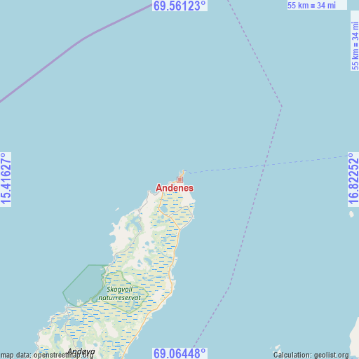
Andenes GPS coordinates[2]
69° 18' 51.408" North, 16° 7' 9.804" East
| Map corner | latitude | longitude |
|---|---|---|
| Upper-left | 69.56123°, | 15.41627° |
| Center: | 69.31428°, | 16.11939° |
| Lower-right: | 69.06448°, | 16.82252° |
| Map W x H: | 55.2×55.2 km | = 34.3×34.3mi |
| max Lat: | 71.04137° ⇑4.6% North |
| Andenes: | 69.31428° |
| min Lat: | ⇓95.4% South 58.0274° |
| min Long | Andenes | max Long |
| 4.71485° | 16.11939° | 31.11066° |
| W 91.5%⇐ | ⇒8.5% E |
Elevation
Elevation of Andenes is 1 m = 3 ft, and this is 103.2 m = 339 ft below average elevation for this country.
| Max E: |
897 m = 2943 ft | 100% |
| Avg. | 104.2 m = 342 ft | |
| Andenes | 1 m = 3 ft | |
Min E: |
1 m = 3 ft | 0% |
See also: Norway elevation on elevation.city.
Geographical zone
Andenes is located in North Frigid zone (between North Pole and Arctic Circle). Distance of this North polar circle is 305.9 km =190.1 mi to South.| Distance of | km | miles | from Andenes |
|---|---|---|---|
| North Pole | 2300 | 1429.2 | to North |
| Arctic Circle | 305.9 | 190.1 | to South |
| Tropic Cancer | 5101.1 | 3169.7 | to South |
| Equator | 7707 | 4788.9 | to South |


Nearby cities:
15 places around Andenes: (largest is in red/bold)
• Borkenes
60.3 km =37.5 mi,  178°
178°
• Brøstadbotn
67.1 km =41.7 mi,  111°
111°
• Evenskjer
83.3 km =51.8 mi,  167°
167°
• Finnsnes
73.9 km =45.9 mi,  97°
97°
• Gryllefjord
37 km =23 mi,  81°
81°
• Hamnvik
72.7 km =45.2 mi,  144°
144°
• Harstad
59.8 km =37.2 mi,  163°
163°
• Myre
24 km =14.9 mi,  194°
194°
• Myre
60.7 km =37.7 mi,  222°
222°
• Sigerfjord
78.4 km =48.7 mi,  198°
198°
• Skaland
48.4 km =30.1 mi,  72°
72°
• Sortland
74.4 km =46.2 mi, 202°
• Strand
73.6 km =45.7 mi, 201°
• Sørreisa
82.4 km =51.2 mi, 103°
• Vangsvika
65.6 km =40.8 mi, 104°
Sources, notices
• [Note1] Compared only with cities in Norway existing in our database
• [Src1] Map data: © OpenStreetMap contributors (CC-BY-SA)
• [Src2] Other city data from geonames.org with taken over terms of usage.
• [Src3] Geographical zone / Annual Mean Temperature by Robert A. Rohde @ Wikipedia
