Hardbakke geodata
Hardbakke (Sogn og Fjordane) is a seat of a second-order administrative division; located in Norway in Europe/Oslo (GMT+2) time zone. With population of 235 people, there are 487 cities with bigger population in this country. Compared to other cities in Norway, 55.9% of cities are located further ↓South; 99.8% of cities are located further →East and 68.4% of cities have lower elevation than Hardbakke. Note1


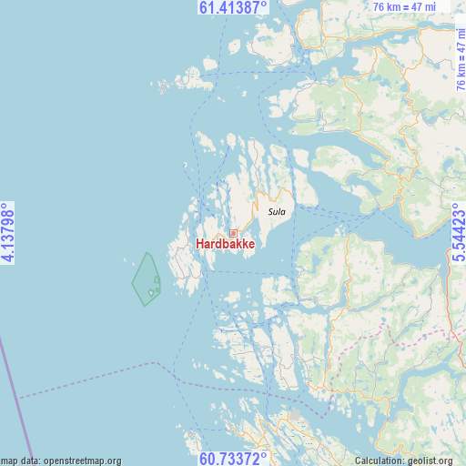
Hardbakke GPS coordinates[2]
61° 4' 32.232" North, 4° 50' 27.996" East
| Map corner | latitude | longitude |
|---|---|---|
| Upper-left | 61.41387°, | 4.13798° |
| Center: | 61.07562°, | 4.84111° |
| Lower-right: | 60.73372°, | 5.54423° |
| Map W x H: | 75.6×75.6 km | = 47×47mi |
| max Lat: | 71.04137° ⇑44.1% North |
| Hardbakke: | 61.07562° |
| min Lat: | ⇓55.9% South 58.0274° |
| min Long | Hardbakke | max Long |
| 4.71485° | 4.84111° | 31.11066° |
| W 0.2%⇐ | ⇒99.8% E |
Elevation
Elevation of Hardbakke is 115 m = 377 ft, and this is 10.8 m = 35 ft above average elevation for this country.
| Max E: |
897 m = 2943 ft | 31.6% |
| Hardbakke | 115 m 377 ft | |
| Avg. | 104.2 m = 342 ft | |
Min E: |
1 m = 3 ft | 68.4% |
See also: Norway elevation on elevation.city.
Geographical zone
Hardbakke is located in North temperate zone (between Tropic of Cancer and the Arctic Circle). Distance of this North polar circle is 610.2 km =379.2 mi to North.| Distance of | km | miles | from Hardbakke |
|---|---|---|---|
| North Pole | 3216.1 | 1998.4 | to North |
| Arctic Circle | 610.2 | 379.2 | to North |
| Tropic Cancer | 4185.1 | 2600.5 | to South |
| Equator | 6791 | 4219.7 | to South |


Nearby cities:
15 places around Hardbakke: (largest is in red/bold)
• Askvoll
32.4 km =20.1 mi,  21°
21°
• Austrheim
33.5 km =20.8 mi,  171°
171°
• Dale
43.8 km =27.2 mi,  43°
43°
• Eivindvik
16.4 km =10.2 mi,  129°
129°
• Fedje
33.7 km =20.9 mi,  191°
191°
• Florø
59.1 km =36.7 mi,  9°
9°
• Hyllestad
26.6 km =16.5 mi,  66°
66°
• Isdalstø
62.4 km =38.8 mi,  158°
158°
• Lindås
41.5 km =25.8 mi, 155°
• Manger
49.5 km =30.8 mi, 167°
• Masfjorden
39.7 km =24.7 mi,  140°
140°
• Mo
59.5 km =37 mi,  118°
118°
• Sande
58.3 km =36.2 mi,  61°
61°
• Tjeldstø
53.3 km =33.1 mi,  179°
179°
• Årås
33.5 km =20.8 mi, 171°
Sources, notices
• [Note1] Compared only with cities in Norway existing in our database
• [Src1] Map data: © OpenStreetMap contributors (CC-BY-SA)
• [Src2] Other city data from geonames.org with taken over terms of usage.
• [Src3] Geographical zone / Annual Mean Temperature by Robert A. Rohde @ Wikipedia
