Hyllestad geodata
Hyllestad (Sogn og Fjordane) is a seat of a second-order administrative division; located in Norway in Europe/Oslo (GMT+2) time zone. In our database, there are 488 cities with bigger population. Compared to other cities in Norway, 57.1% of cities are located further ↓South; 94% of cities are located further →East and 71.5% of cities have lower elevation than Hyllestad. Note1


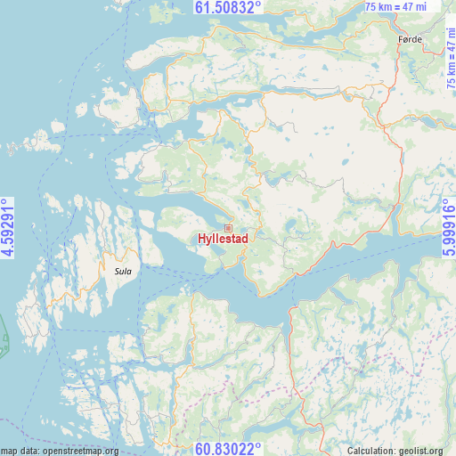
Hyllestad GPS coordinates[2]
61° 10' 15.924" North, 5° 17' 45.708" East
| Map corner | latitude | longitude |
|---|---|---|
| Upper-left | 61.50832°, | 4.59291° |
| Center: | 61.17109°, | 5.29603° |
| Lower-right: | 60.83022°, | 5.99916° |
| Map W x H: | 75.4×75.4 km | = 46.9×46.9mi |
| max Lat: | 71.04137° ⇑42.9% North |
| Hyllestad: | 61.17109° |
| min Lat: | ⇓57.1% South 58.0274° |
| min Long | Hyllestad | max Long |
| 4.71485° | 5.29603° | 31.11066° |
| W 6%⇐ | ⇒94% E |
Elevation
Elevation of Hyllestad is 130 m = 427 ft, and this is 25.8 m = 85 ft above average elevation for this country.
| Max E: |
897 m = 2943 ft | 28.5% |
| Hyllestad | 130 m 427 ft | |
| Avg. | 104.2 m = 342 ft | |
Min E: |
1 m = 3 ft | 71.5% |
See also: Norway elevation on elevation.city.
Geographical zone
Hyllestad is located in North temperate zone (between Tropic of Cancer and the Arctic Circle). Distance of this North polar circle is 599.6 km =372.6 mi to North.| Distance of | km | miles | from Hyllestad |
|---|---|---|---|
| North Pole | 3205.5 | 1991.8 | to North |
| Arctic Circle | 599.6 | 372.6 | to North |
| Tropic Cancer | 4195.7 | 2607.1 | to South |
| Equator | 6801.6 | 4226.3 | to South |


Nearby cities:
15 places around Hyllestad: (largest is in red/bold)
• Askvoll
23.2 km =14.4 mi,  327°
327°
• Austrheim
48 km =29.8 mi,  204°
204°
• Dale
22.1 km =13.7 mi,  14°
14°
• Eivindvik
24.2 km =15 mi,  209°
209°
• Fedje
53.7 km =33.4 mi,  215°
215°
• Florø
49.7 km =30.9 mi,  343°
343°
• Førde
43.3 km =26.9 mi,  43°
43°
• Hardbakke
26.6 km =16.5 mi,  246°
246°
• Høyanger
42.6 km =26.5 mi,  82°
82°
• Lindås
48.9 km =30.4 mi,  188°
188°
• Masfjorden
41.4 km =25.7 mi,  179°
179°
• Mo
48.1 km =29.9 mi,  145°
145°
• Naustdal
44 km =27.3 mi,  30°
30°
• Sande
31.8 km =19.8 mi,  57°
57°
• Årås
48 km =29.8 mi, 204°
Sources, notices
• [Note1] Compared only with cities in Norway existing in our database
• [Src1] Map data: © OpenStreetMap contributors (CC-BY-SA)
• [Src2] Other city data from geonames.org with taken over terms of usage.
• [Src3] Geographical zone / Annual Mean Temperature by Robert A. Rohde @ Wikipedia
