Sogndal geodata
Sogndal (Sogn og Fjordane) is a populated place; located in Norway in Europe/Oslo (GMT+2) time zone. With population of 6,700 people, there are 66 cities with bigger population in this country. Compared to other cities in Norway, 58.5% of cities are located further ↓South; 72.8% of cities are located further →East and 100% of cities have higher elevation than Sogndal. Note1


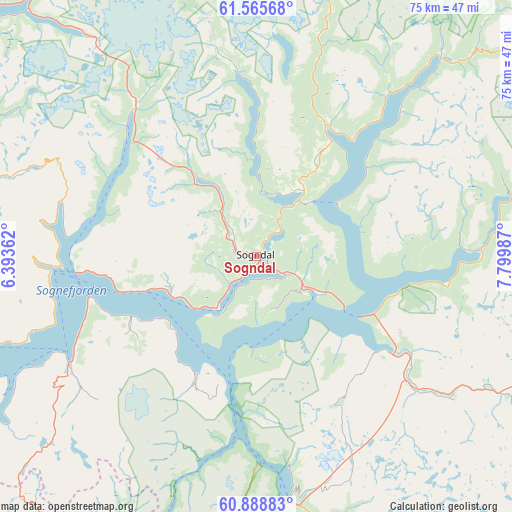
Sogndal GPS coordinates[2]
61° 13' 44.688" North, 7° 5' 48.264" East
| Map corner | latitude | longitude |
|---|---|---|
| Upper-left | 61.56568°, | 6.39362° |
| Center: | 61.22908°, | 7.09674° |
| Lower-right: | 60.88883°, | 7.79987° |
| Map W x H: | 75.3×75.3 km | = 46.8×46.8mi |
| max Lat: | 71.04137° ⇑41.5% North |
| Sogndal: | 61.22908° |
| min Lat: | ⇓58.5% South 58.0274° |
| min Long | Sogndal | max Long |
| 4.71485° | 7.09674° | 31.11066° |
| W 27.2%⇐ | ⇒72.8% E |
Elevation
Elevation of Sogndal is 1 m = 3 ft, and this is 103.2 m = 339 ft below average elevation for this country.
| Max E: |
897 m = 2943 ft | 100% |
| Avg. | 104.2 m = 342 ft | |
| Sogndal | 1 m = 3 ft | |
Min E: |
1 m = 3 ft | 0% |
See also: Norway elevation on elevation.city.
Geographical zone
Sogndal is located in North temperate zone (between Tropic of Cancer and the Arctic Circle). Distance of this North polar circle is 593.1 km =368.5 mi to North.| Distance of | km | miles | from Sogndal |
|---|---|---|---|
| North Pole | 3199 | 1987.8 | to North |
| Arctic Circle | 593.1 | 368.5 | to North |
| Tropic Cancer | 4202.1 | 2611.1 | to South |
| Equator | 6808 | 4230.3 | to South |


Nearby cities:
15 places around Sogndal: (largest is in red/bold)
• Aurlandsvangen
36.3 km =22.6 mi,  172°
172°
• Balestrand
30.1 km =18.7 mi,  265°
265°
• Farnes
38.5 km =23.9 mi,  76°
76°
• Førde
70.6 km =43.9 mi,  290°
290°
• Gaupne
22.2 km =13.8 mi,  28°
28°
• Hermansverk
14.1 km =8.8 mi,  249°
249°
• Høyanger
54.2 km =33.7 mi, 269°
• Kaupanger
9.2 km =5.7 mi,  122°
122°
• Lærdalsøyri
24.8 km =15.4 mi,  125°
125°
• Sande
70.2 km =43.6 mi,  278°
278°
• Skei
50.3 km =31.3 mi,  319°
319°
• Sogndalsfjøra
0.5 km =0.3 mi,  143°
143°
• Vik
33.8 km =21 mi,  235°
235°
• Vikøyri
31.9 km =19.8 mi, 240°
• Årdalstangen
32.5 km =20.2 mi,  88°
88°
Sources, notices
• [Note1] Compared only with cities in Norway existing in our database
• [Src1] Map data: © OpenStreetMap contributors (CC-BY-SA)
• [Src2] Other city data from geonames.org with taken over terms of usage.
• [Src3] Geographical zone / Annual Mean Temperature by Robert A. Rohde @ Wikipedia
